
Remote Sensing
Remote Sensing
“the art, science, and technology of obtaining
“the art, science, and technology of obtaining
reliable information about physical objects and the
reliable information about physical objects and the
environment, through the process of recording,
environment, through the process of recording,
measuring and interpreting imagery and digital
measuring and interpreting imagery and digital
measuring and interpreting imagery and digital
measuring and interpreting imagery and digital
representations of energy patterns derived from
representations of energy patterns derived from
noncontact sensor systems”. (Cowell 1997)
noncontact sensor systems”. (Cowell 1997)
Taken from: Introductory Digital Image Processing. 3
Taken from: Introductory Digital Image Processing. 3
rd
rd
edition.
edition.
Jensen, 2004
Jensen, 2004
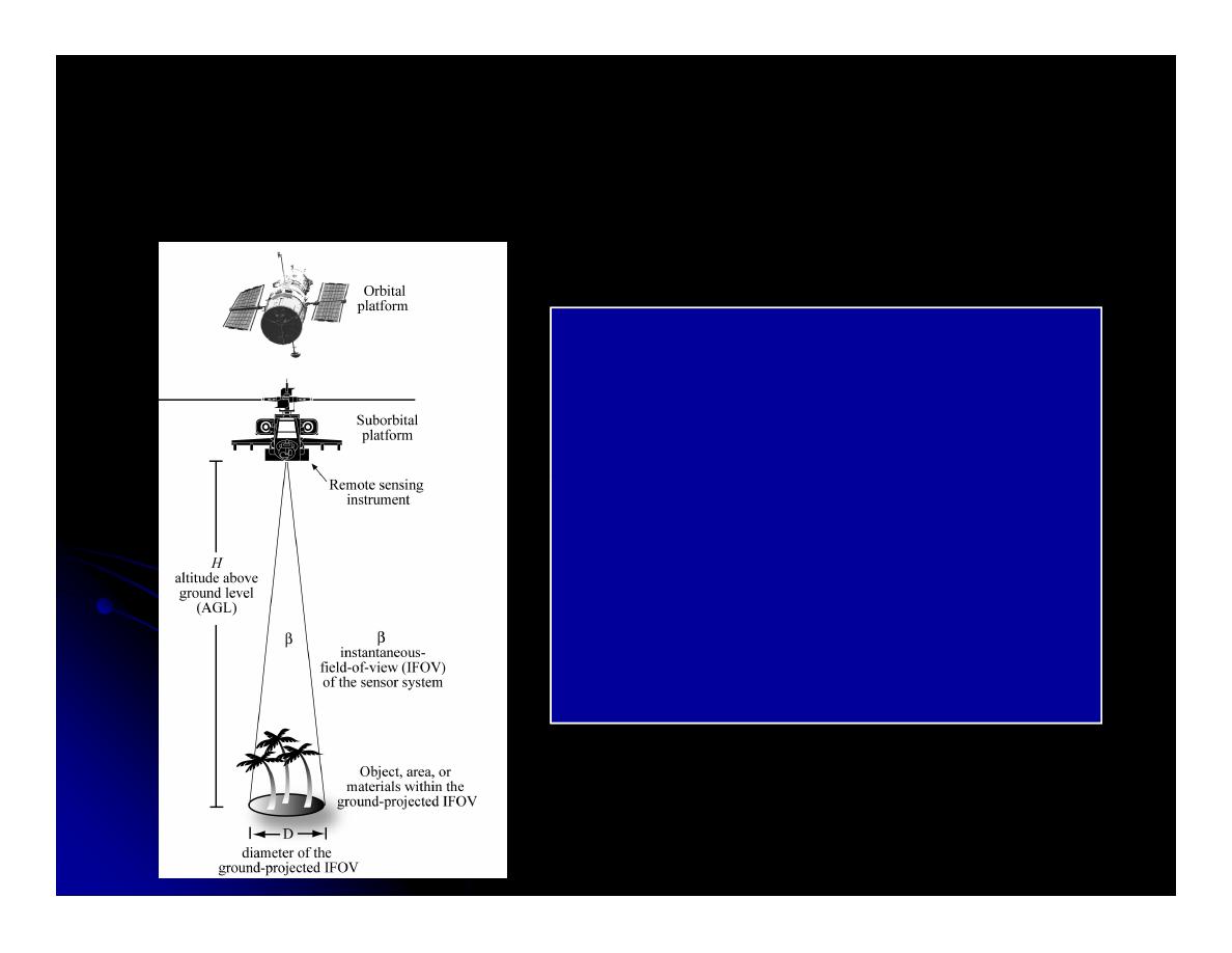
Remote Sensing
Remote Sensing
A remote sensing instrument
collects information about an
object or phenomenon within the
instantaneous-field-of-view
instantaneous-field-of-view
(IFOV) of the sensor system
without being in direct physical
contact with it. The sensor is
located on a suborbital
or satellite platform.
Introductory Digital Image Processing. 3rd edition. Jensen, 2004
Introductory Digital Image Processing. 3rd edition. Jensen, 2004
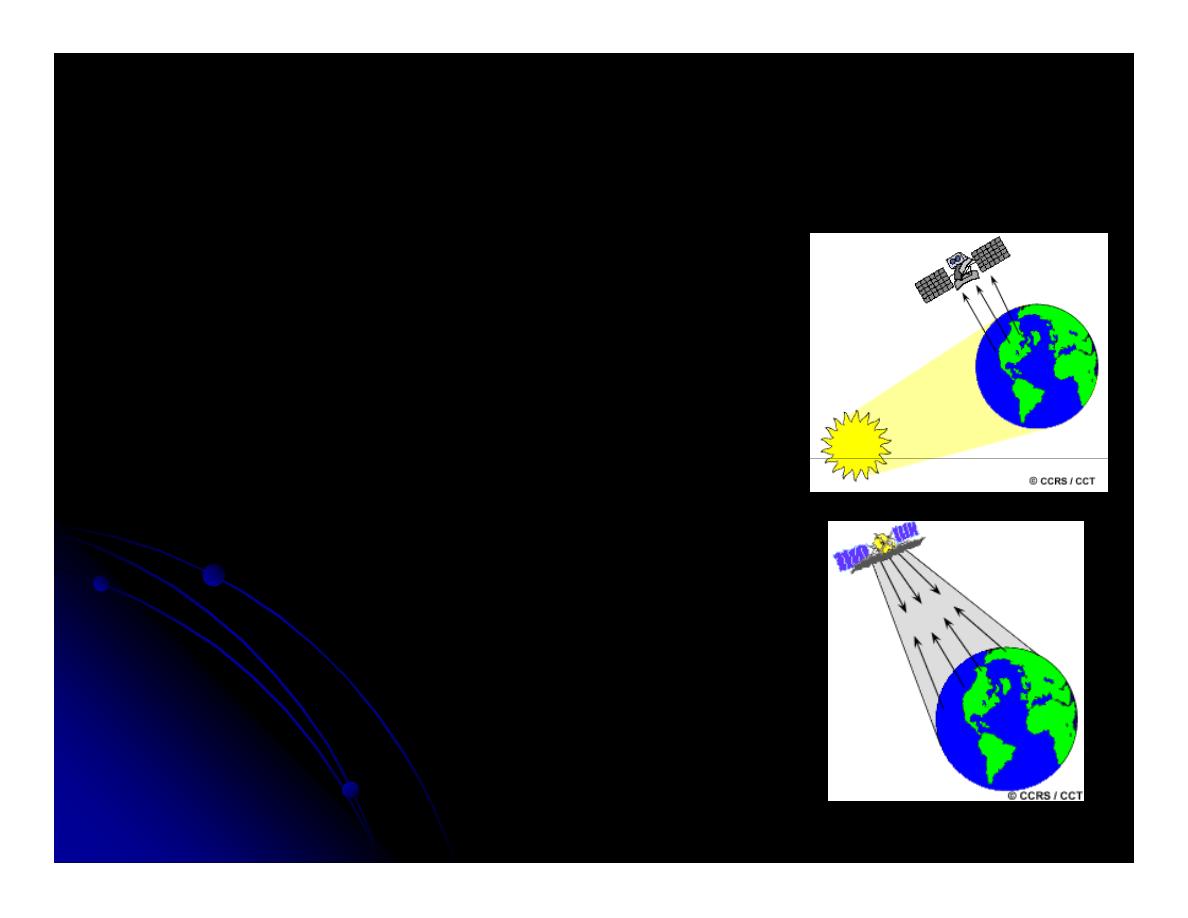
Sensors
Sensors
Passive
Passive
Sun’s energy which is reflected
Sun’s energy which is reflected
(visible) or
(visible) or
Absorbed and re
Absorbed and re--emitted as
emitted as
thermal infrared wavelengths
thermal infrared wavelengths
thermal infrared wavelengths
thermal infrared wavelengths
ASTER, Landsat, AVHRR
ASTER, Landsat, AVHRR
Active
Active
Emit radiation
Emit radiation
Radiation reflected is detected and
Radiation reflected is detected and
measured
measured
LIDAR, RADAR, and SONAR
LIDAR, RADAR, and SONAR
http://ccrs.nrcan.gc.ca/resource/tutor/fundam/chapter1/06_e.php
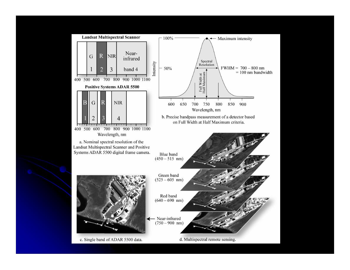
Spectral Resolution
Spectral Resolution
Introductory Digital Image Processing. 3rd edition. Jensen, 2004
Introductory Digital Image Processing. 3rd edition. Jensen, 2004
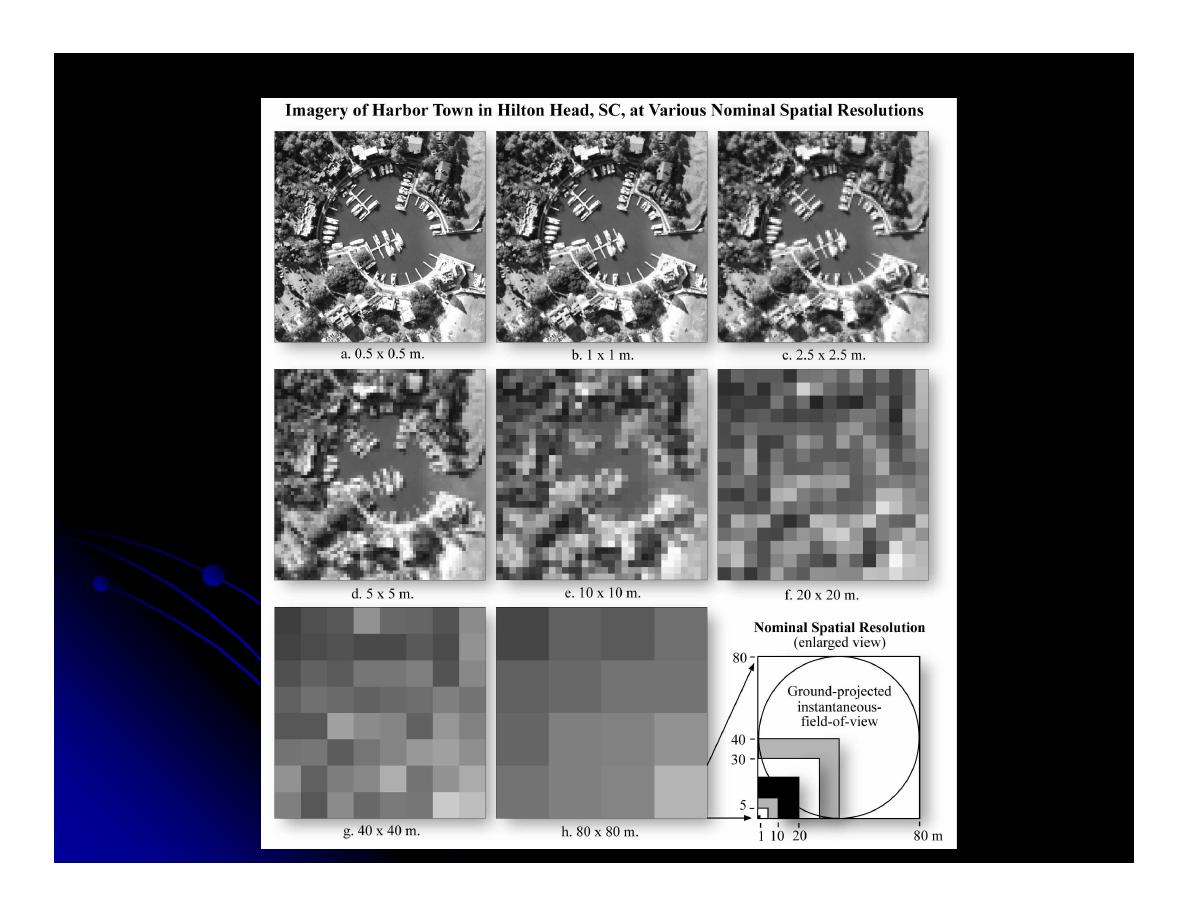
Spatial
Spatial Resolution
Resolution
Introductory Digital Image Processing. 3rd edition. Jensen, 2004
Introductory Digital Image Processing. 3rd edition. Jensen, 2004

MODIS
MODIS
Moderate Resolution Imaging
Moderate Resolution Imaging
Spectroradiometer
Spectroradiometer
Launched in 1999 on NASA’s Earth
Launched in 1999 on NASA’s Earth
Orbiting System (EOS) platform
Orbiting System (EOS) platform
Orbiting System (EOS) platform
Orbiting System (EOS) platform
36 spectral bands
36 spectral bands
http://terra.nasa.gov/About/MODIS/modis_
http://terra.nasa.gov/About/MODIS/modis_
swath.html
swath.html

MODVOLC
MODVOLC
Algorithm created by University of Hawaii
Algorithm created by University of Hawaii
“The MODVOLC algorithm automatically
“The MODVOLC algorithm automatically
scans each 1 kilometer pixel within it to
scans each 1 kilometer pixel within it to
check for the presence of high
check for the presence of high--
check for the presence of high
check for the presence of high--
temperature hot
temperature hot--spots.”
spots.”
Used not only for volcanic eruptions, but
Used not only for volcanic eruptions, but
wildfires as well.
wildfires as well.
http://modis.higp.hawaii.edu/
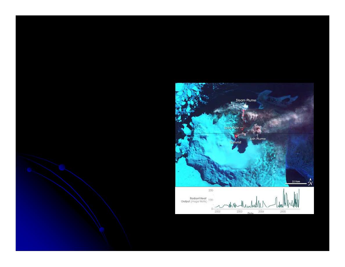
Mount Belinda
Mount Belinda
South Sandwich Islands
South Sandwich Islands
Eruption first recorded
Eruption first recorded
using MODVOLC
using MODVOLC
Used MODIS, Landsat
Used MODIS, Landsat
7ETM+, ASTER, and
7ETM+, ASTER, and
RADARSAT
RADARSAT--1
1
Identified first recorded
Identified first recorded
eruption ever
eruption ever
http://www.intute.ac.uk/sciences/worldguide/satellite/2374.jpg
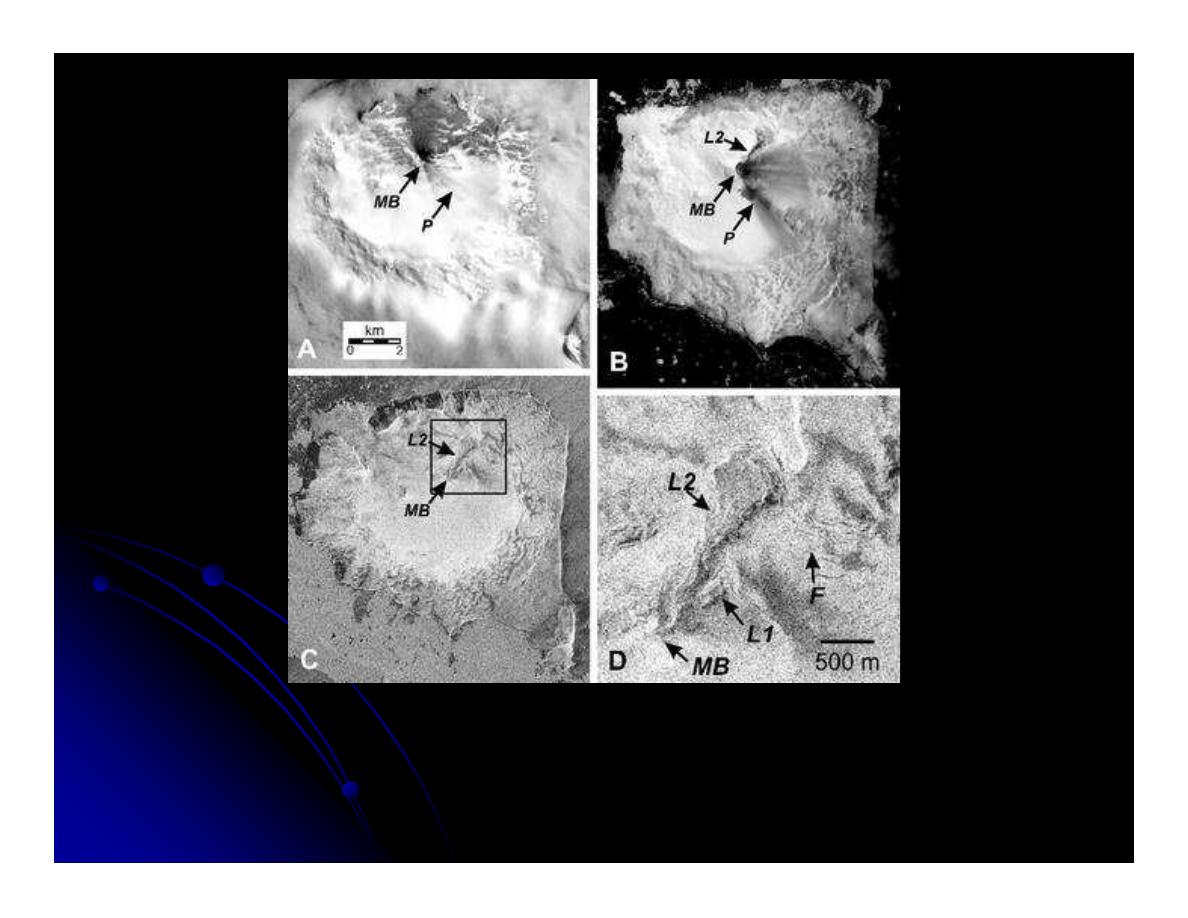
Selected high spatial-resolution images of Montagu Island. North is up. A) Landsat 7 ETM+ Band 8 image from 4 Jan
2002 showing diffuse plume (P) emanating from Mount Belinda s summit (MB) and tephra deposits on north flank.
Scale bar applies to A, B and C. B) ASTER visible band composite image (Bands 3–2-1) on 7 Dec 2003, showing
tephra deposits and 2003 lava flow (L2). C) RADARSAT-1 image from 30 Oct 2003 showing recent morphology, with
inset (D). Arrows point to approximate summit of Mount Belinda and vent location (MB), ash plumes (P), 600 m long
lava flow first observed in Jan 2002 (L1), entrenched 2 km long lava flow first observed in Aug 2003 (L2), and arcuate
fractures unrelated to this eruption (F). RADARSAT image was provided by the Alaska Satellite Facility, and is
copyright 2003 CSA

ASTER
ASTER
Advanced Spaceborne Thermal Emission
Advanced Spaceborne Thermal Emission
and Reflection Radiometer
and Reflection Radiometer
Launched in 1999, part of NASA’s EOS
Launched in 1999, part of NASA’s EOS
Spatial Resolution 15m(VNIR),
Spatial Resolution 15m(VNIR),
Spatial Resolution 15m(VNIR),
Spatial Resolution 15m(VNIR),
30m(SWIR), 90(TIR). 16 day temporal
30m(SWIR), 90(TIR). 16 day temporal
resolution possible
resolution possible
Per request basis
Per request basis

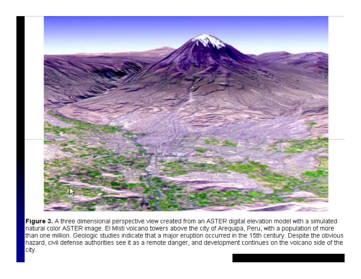
ASTER Uses
ASTER Uses
Volcanological Studies
Volcanological Studies
Mineralogical Studies
Mineralogical Studies
Hydrothermal Studies
Hydrothermal Studies
Forest Fires
Forest Fires
Forest Fires
Forest Fires
Glacier Studies
Glacier Studies
Limnological Studies
Limnological Studies
Climatology Studies
Climatology Studies
Digital Elevation Models
Digital Elevation Models
http://asterweb.jpl.nasa.gov/gallerymap.asp
http://asterweb.jpl.nasa.gov/gallerymap.asp
http://asterweb.jpl.nasa.gov/content/03_data/05_Application_Examples/volcanology/default.htm
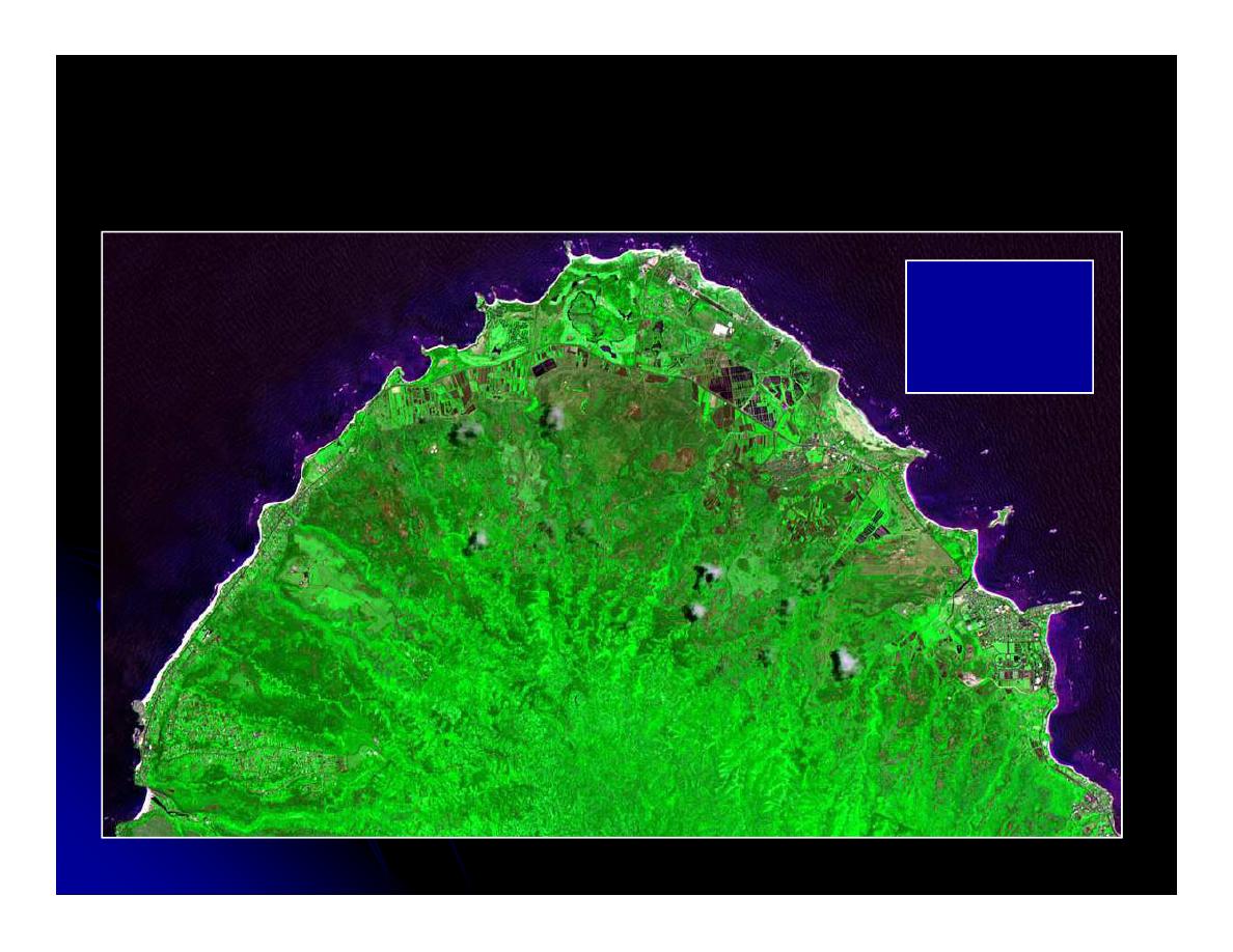
North Shore
Oahu, HI
Oahu, HI
15 x 15 m
15 x 15 m
(RGB= 1,4,3)
(RGB= 1,4,3)
ASTER
ASTER
LANDSAT
LANDSAT
Launched in 1972,
Launched in 1972,
Managed by NASA and
Managed by NASA and
USGS
USGS
ETM 7+ has 7 bands (30
ETM 7+ has 7 bands (30
and 60 m) and a
and 60 m) and a
and 60 m) and a
and 60 m) and a
panchromatic (15)
panchromatic (15)
Collected every 16 days
Collected every 16 days
Mapping lava flows,
Mapping lava flows,
thermal monitoring,
thermal monitoring,
extrusion rates
extrusion rates
Introductory Digital Image Processing. 3rd edition. Jensen, 2004
Introductory Digital Image Processing. 3rd edition. Jensen, 2004
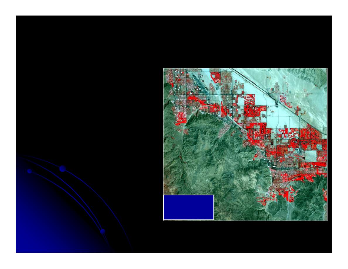
Landsat 7 Image of
Landsat 7 Image of
Palm Spring, CA
Palm Spring, CA
30 x 30 m
30 x 30 m
(bands 4,3,2 = RGB)
(bands 4,3,2 = RGB)

AVHRR
AVHRR
Advanced Very High Resolution
Advanced Very High Resolution
Radiometer
Radiometer
First launched in 1978 by NOAA
First launched in 1978 by NOAA
Global coverage 4.4 km, U.S 1 km (low
Global coverage 4.4 km, U.S 1 km (low
Global coverage 4.4 km, U.S 1 km (low
Global coverage 4.4 km, U.S 1 km (low
spatial resolution
spatial resolution
Collected twice a day (High temporal
Collected twice a day (High temporal
resolution)
resolution)
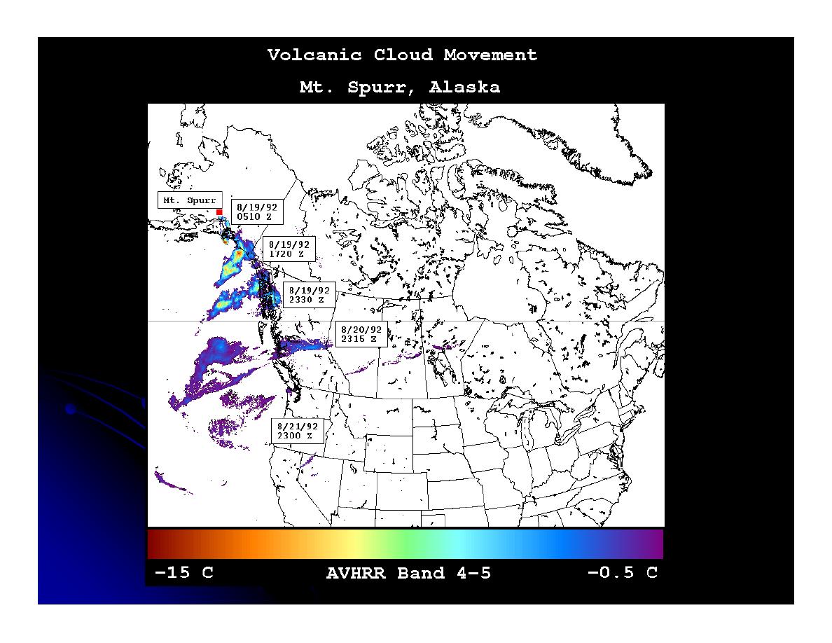
http://www.geo.mtu.edu/volcanoes/research/avhrr/images/spurr/
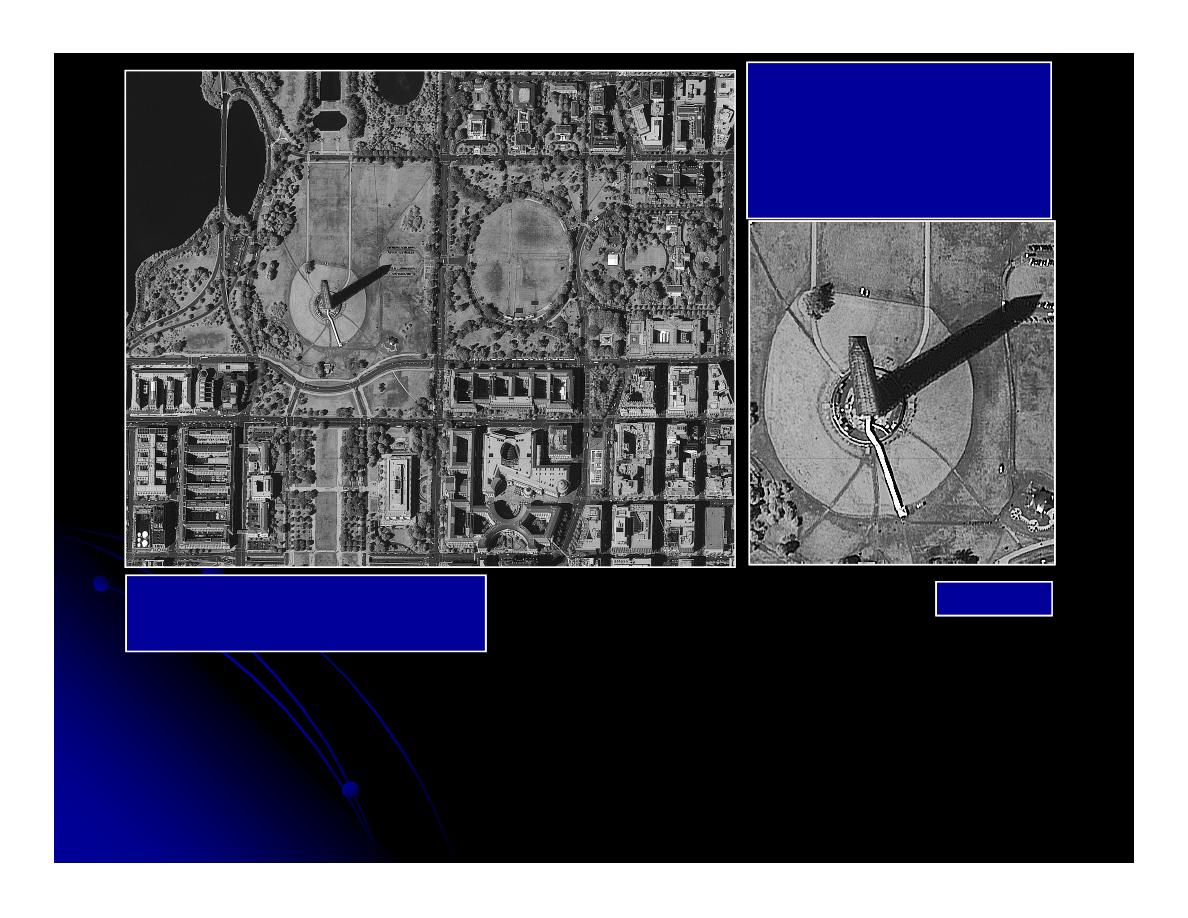
IKONOS
IKONOS
Panchromatic Images
Panchromatic Images
of Washington, DC
of Washington, DC
Jensen, 2004
1 x 1 m spatial resolution
1 x 1 m spatial resolution
First satellite launched by a private company, launched in 1999
1 meter panchromatic, 4 m visible and near infrared

Active Sensors
Active Sensors
Emits energy pulse, measure backscatter,
Emits energy pulse, measure backscatter,
records as a digital number
records as a digital number
Long wavelength
Long wavelength--microwave
microwave
Long wavelength
Long wavelength--microwave
microwave
Penetrates clouds and vegetation
Penetrates clouds and vegetation
RADAR always black and white with speckled
RADAR always black and white with speckled
texture
texture
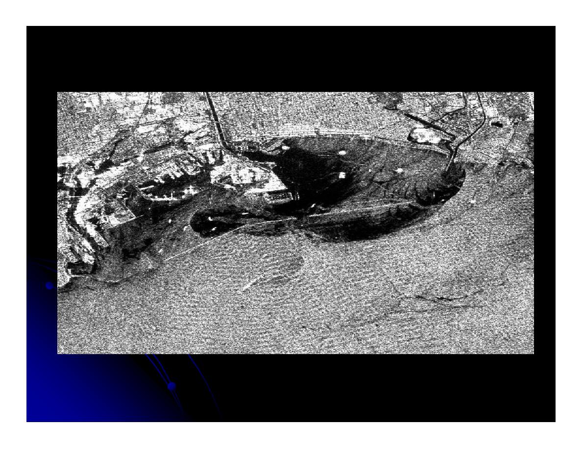
RADAR
RADAR
http://www.jpl.nasa.gov/images/earth/california/sar-la-browse.jpg
European Remote Sensing 1 satellite radar image of stormwater runoff plumes from Los
Angeles and San Gabriel Rivers into the Los Angeles and Long Beach Harbors. Dec. 28,
1992. Image credit: ESA

LIDAR
LIDAR
Light Detection and Ranging
Light Detection and Ranging
Transmits a laser light to target
Transmits a laser light to target
15 cm accuracy
15 cm accuracy
http://vulcan.wr.usgs.gov/Volcanoes/MSH/
http://vulcan.wr.usgs.gov/Volcanoes/MSH/
Eruption04/LIDAR/
Eruption04/LIDAR/