Fundamentals
(
Geo
graphic Information Systems
)

2
9/28/2015 Ron Briggs, UTDallas, GIS Fundamentals
GIS--What is it?
No easy answer anymore!
• Geographic/Geospatial Information
– information about places on the earth’s surface
– knowledge about “what is where when”
(Don’t forget time!)
– Geographic/geospatial: synonymous
• GIS--what’s in the S?
– Systems: the technology
– Science: the concepts and theory
– Studies: the societal context

3
9/28/2015 Ron Briggs, UTDallas, GIS Fundamentals
Geographic Information Technologies
• Global Positioning Systems (GPS)
– a system of earth-orbiting satellites which can provide precise
(100 meter to sub-cm.) location on the earth’s surface (in lat/long
coordinates or equiv.)
• Remote Sensing (RS)
– use of satellites or aircraft to capture information about the
earth’s surface
– Digital ortho images a key product (map accurate digital photos)
• Geographic Information Systems (GISy)
– Software systems with capability for input, storage,
manipulation/analysis and output/display of geographic (spatial)
information
GPS and RS are sources of input data for a GISy.
A GISy provides for storing and manipulating GPS and RS data.

4
9/28/2015 Ron Briggs, UTDallas, GIS Fundamentals
Defining Geographic Information Systems
(GIS)
• The common ground between information processing and
the many fields using spatial analysis techniques.
(Tomlinson, 1972)
• A powerful set of tools for collecting, storing, retrieving,
transforming, and displaying spatial data from the real
world. (Burroughs, 1986)
• A computerised database management system for the
capture, storage, retrieval, analysis and display of spatial
(locationally defined) data. (NCGIA, 1987)
• A decision support system involving the integration of
spatially referenced data in a problem solving
environment. (Cowen, 1988)

5
9/28/2015 Ron Briggs, UTDallas, GIS Fundamentals
Geographic Information System:
intuitive description
• A map with a database behind it.
• A virtual representation of the
real world and its infrastructure.
• A consistent “as-built” of the
real world, natural and manmade
Which is
• queried to support on-going
operations
• summarized to support strategic
decision making and policy
formulation
• analyzed to support scientific
inquiry

6
9/28/2015 Ron Briggs, UTDallas, GIS Fundamentals
Why Study GIS?
• 80% of local government activities estimated to be geographically based
– plats, zoning, public works (streets, water supply, sewers), garbage collection, land
ownership and valuation, public safety (fire and police)
• a significant portion of state government has a geographical component
– natural resource management
– highways and transportation
• businesses use GIS for a very wide array of applications
– retail site selection & customer analysis
– logistics: vehicle tracking & routing
– natural resource exploration (petroleum, etc.)
– precision agriculture
– civil engineering and construction
• Military and defense
– Battlefield management
– Satellite imagery interpretation
• scientific research employs GIS
– geography, geology, botany
– anthropology, sociology, economics, political science
– Epidemiology, criminology

7
9/28/2015 Ron Briggs, UTDallas, GIS Fundamentals
The major areas of GIS application
• Local Government
– Public works/infrastructure management (roads, water, sewer)
– Planning and environmental management
– property records and appraisal
• Real Estate and Marketing
– Retail site selection, site evaluation
• Public safety and defense
– Crime analysis, fire prevention, emergency management, military/defense
• Natural resource exploration/extraction
– Petroleum, minerals, quarrying
• Transportation
– Airline route planning, transportation planning/modeling
• Public health and epidemiology
• The Geospatial Industry
– Data development, application development, programming

8
9/28/2015 Ron Briggs, UTDallas, GIS Fundamentals
Examples of Applied GIS
•
Urban Planning, Management &
Policy
– Zoning, subdivision planning
– Land acquisition
– Economic development
– Code enforcement
– Housing renovation programs
– Emergency response
– Crime analysis
– Tax assessment
•
Environmental Sciences
– Monitoring environmental risk
– Modeling stormwater runoff
– Management of watersheds,
floodplains, wetlands, forests, aquifers
– Environmental Impact Analysis
– Hazardous or toxic facility siting
– Groundwater modeling and
contamination tracking
•
Political Science
– Redistricting
– Analysis of election results
– Predictive modeling
•
Civil Engineering/Utility
– Locating underground facilities
– Designing alignment for freeways, transit
– Coordination of infrastructure maintenance
•
Business
– Demographic Analysis
– Market Penetration/ Share Analysis
– Site Selection
•
Education Administration
–
Attendance Area Maintenance
–
Enrollment Projections
–
School Bus Routing
•
Real Estate
– Neighborhood land prices
– Traffic Impact Analysis
– Determination of Highest and Best Use
•
Health Care
– Epidemiology
–
Needs Analysis
–
Service Inventory

9
9/28/2015 Ron Briggs, UTDallas, GIS Fundamentals
What GIS Applications Do:
manage, analyze, communicate
• make possible the automation of activities involving geographic data
– map production
– calculation of areas, distances, route lengths
– measurement of slope, aspect, viewshed
– logistics: route planning, vehicle tracking, traffic management
• allow for the integration of data hitherto confined to independent domains
(e.g property maps and air photos).
• by tieing data to maps, permits the succinct communication of complex
spatial patterns (e.g environmental sensitivity).
• provides answers to spatial queries (how many elderly in Richardson live
further than 10 minutes at rush hour from ambulance service?)
• perform complex spatial modelling (what if scenarios for transportation
planning, disaster planning, resource management, utility design)
10
9/28/2015 Ron Briggs, UTDallas, GIS Fundamentals
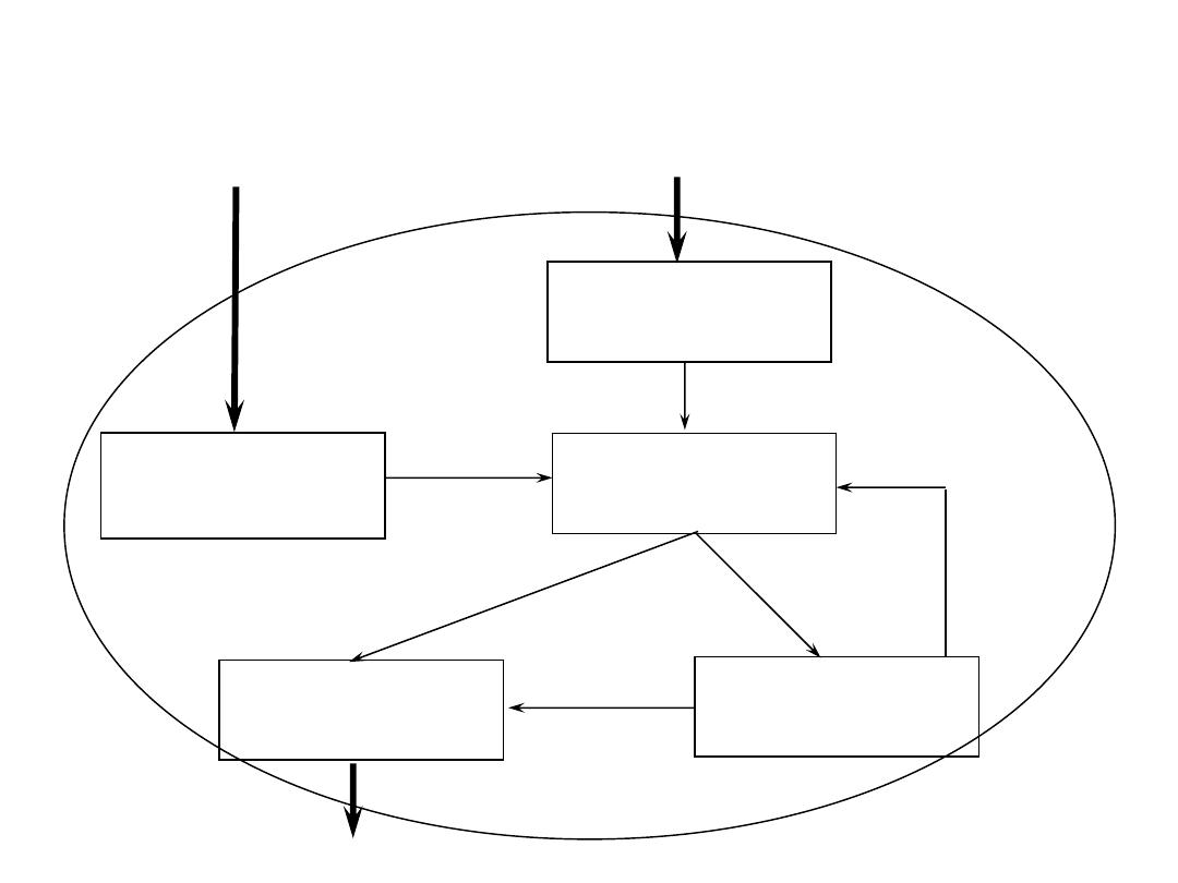
GIS System Architecture and Components
Data Input
Query Input
Geographic
Database
Output: Display
and Reporting
Transformation
and Analysis

11
9/28/2015 Ron Briggs, UTDallas, GIS Fundamentals
Knowledge Base for GIS
GIS
Application Area:
public admin.
planning
geology
mineral exploration
forestry
site selection
marketing
civil engineering
criminal justice
surveying
Computer
Science/MIS
graphics
visualization
database
system administration
security
Geography
and related:
cartography
geodesy
photogrammetry
landforms
spatial statistics.
The convergence of technological
fields and traditional disciplines.

12
9/28/2015 Ron Briggs, UTDallas, GIS Fundamentals
The GIS Data Model

13
9/28/2015 Ron Briggs, UTDallas, GIS Fundamentals
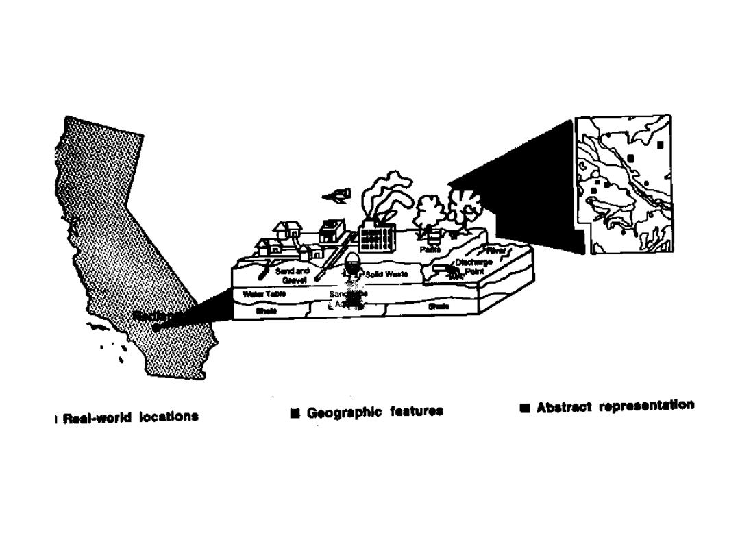
The GIS Data Model: Purpose
• allows the geographic features in real
world locations to be digitally represented
and stored in a database so that they can be
abstractly presented in map (analog) form,
and can also be worked with and
manipulated to address some problem
(see associated diagrams)
14
9/28/2015 Ron Briggs, UTDallas, GIS Fundamentals
15
9/28/2015 Ron Briggs, UTDallas, GIS Fundamentals
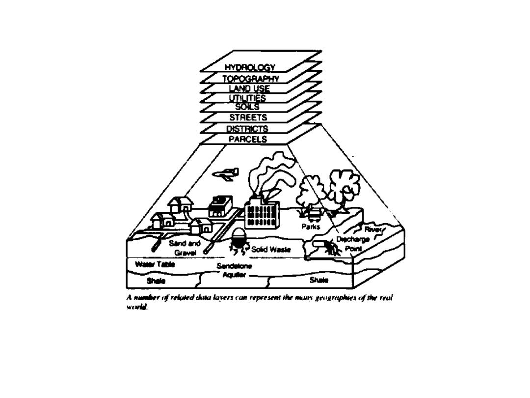
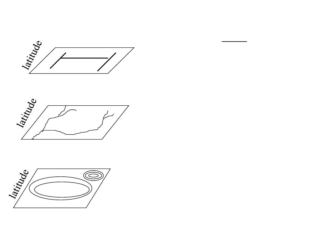
GIS Data Model
A layer-cake of information
16
9/28/2015 Ron Briggs, UTDallas, GIS Fundamentals
The GIS Model: example
roads
hydrology
topography
Here we have three layers or themes:
--roads,
--hydrology (water),
--topography (land elevation)
They can be related because precise geographic
coordinates are recorded for each theme.
longitude
longitude
longitude
Layers are comprised of two data types
•Spatial data which describes location (where)
•Attribute data specifing what, how much,when
Layers may be represented in two ways:
•in vector format as points and lines
•in raster(or image) format as pixels
All geographic data has 4 properties:
projection, scale, accuracy and resolution

17
9/28/2015 Ron Briggs, UTDallas, GIS Fundamentals
Spatial and Attribute Data
• Spatial data (where)
– specifies location
– stored in a shape file, geodatabase or similar geographic file
• Attribute (descriptive) data (what, how much, when)
– specifies characteristics at that location, natural or human-
created
– stored in a data base table
GIS systems traditionally maintain spatial and attribute data
separately, then “join” them for display or analysis
– for example, in ArcView, the Attributes of … table is used to
link a shapefile (spatial structure) with a data base table
containing attribute information in order to display the attribute
data spatially on a map

18
9/28/2015 Ron Briggs, UTDallas, GIS Fundamentals
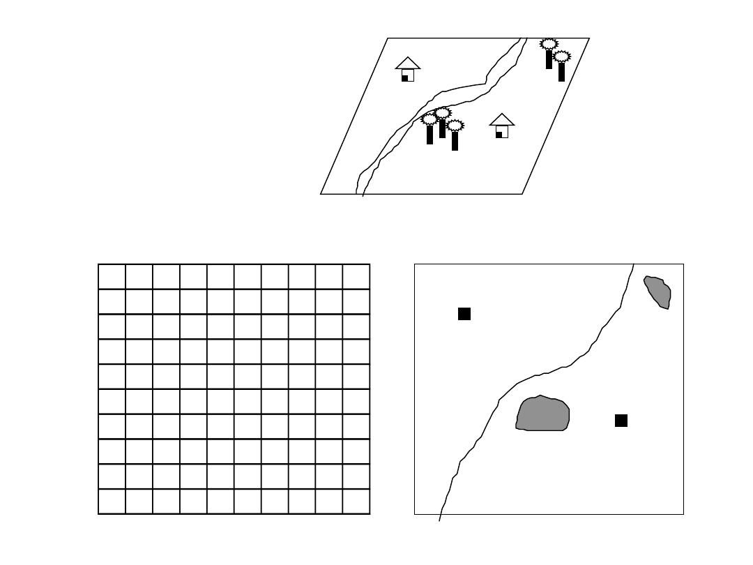
Representing Data with Raster and Vector Models
Raster Model
• area is covered by grid with (usually) equal-sized, square cells
• attributes are recorded by assigning each cell a single value
based on the majority feature (attribute) in the cell, such as land
use type.
• Image data is a special case of raster data in which the “attribute”
is a reflectance value from the geomagnetic spectrum
– cells in image data often called pixels (picture elements)
• Vector Model
The fundamental concept of vector GIS is that all geographic
features in the real work can be represented either as:
• points or dots (nodes): trees, poles, fire plugs, airports, cities
• lines (arcs): streams, streets, sewers,
• areas (polygons): land parcels, cities, counties, forest, rock type
Because representation depends on shape, ArcView refers to files containing
vector data as shapefiles
19
9/28/2015 Ron Briggs, UTDallas, GIS Fundamentals
0
1
2
3
4
5
6
7
8
9
0
R T
1
R
T
2
H
R
3
R
4
R R
5
R
6
R
T
T
H
7
R
T
T
8
R
9
R
Real World
Vector Representation
Raster Representation
Concept of
Vector and Raster
line
polygon
point
20
9/28/2015 Ron Briggs, UTDallas, GIS Fundamentals
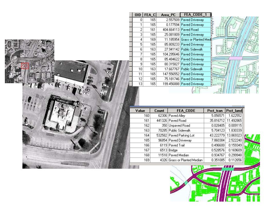
Images—dumb rasters
(although they look good!)
Smart Raster—5 feet grids
Smart Vector—Pavement polygons
Dumb Images
& Smart GIS Data

21
9/28/2015 Ron Briggs, UTDallas, GIS Fundamentals
Projection, Scale, Accuracy and Resolution
the key properties of spatial data
• Projection: the method by which the curved 3-D surface of the
earth is represented by X,Y coordinates on a 2-D flat map/screen
– distortion is inevitable
• Scale: the ratio of distance on a map to the equivalent distance on
the ground
– in theory GIS is scale independent but in practice there is an implicit range of
scales for data output in any project
• Accuracy: how well does the database info match the real world
– Positional: how close are features to their real world location?
– Consistency: do feature characteristics in database match those in real world
• is a road in the database a road in the real world?
– Completeness: are all real world instances of features present in the database?
• Are all roads included.
• Resolution: the size of the smallest feature able to be recognized
– for raster data, it is the pixel size
The tighter the specification, the higher the cost.

22
9/28/2015 Ron Briggs, UTDallas, GIS Fundamentals
Examples
23
9/28/2015 Ron Briggs, UTDallas, GIS Fundamentals
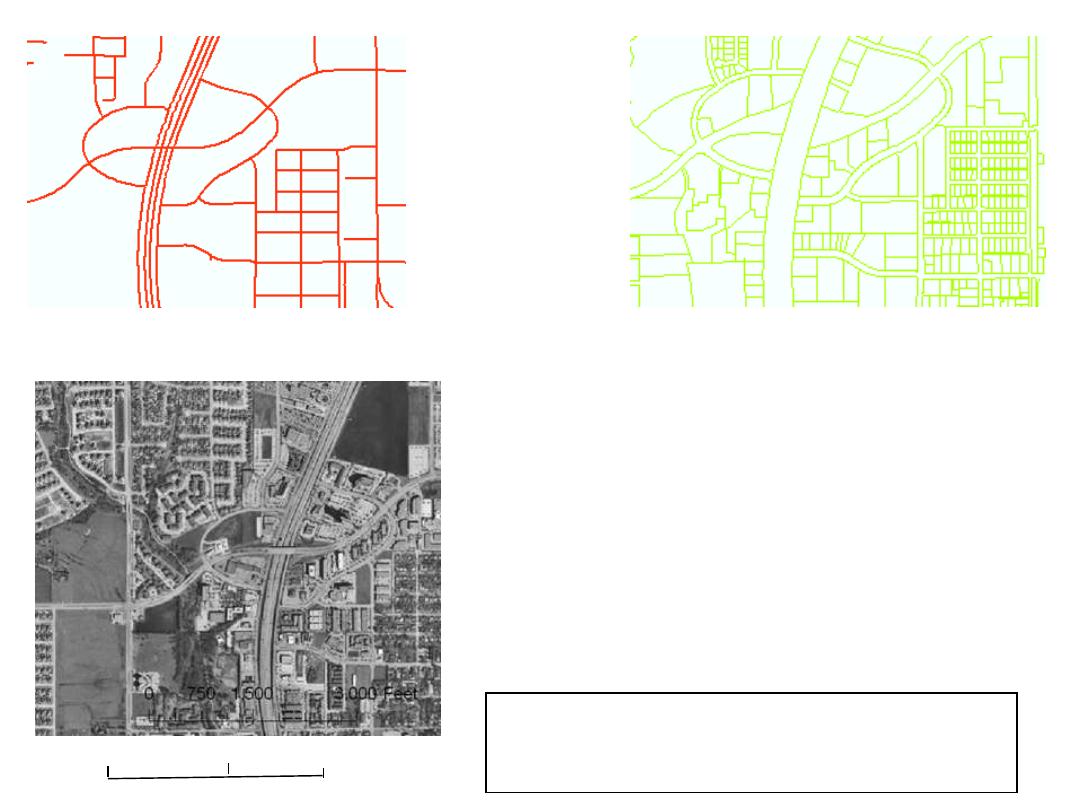
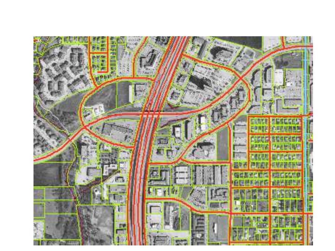
Street Network layer: lines
Land Parcels layer: polygons
Raster (image) Layer
Digital Ortho Photograph Layer:
Digital Ortho photo: combines the
visual properties of a photograph
with the positional accuracy of a
map, in computer readable form.
Vector
Layers
Layers
Projection: State Plane, North Central Texas Zone, NAD 83
Resolution: 0.5 meters
Accuracy: 1.0 meters
Scale:
see scale bar
0
1500
3000 Feet
24
9/28/2015 Ron Briggs, UTDallas, GIS Fundamentals
Overlay based on Common Geographic Location
25
9/28/2015 Ron Briggs, UTDallas, GIS Fundamentals
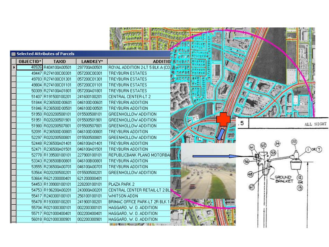
Parcels within a half mile buffer of Park and Central
Photographic Image
Scanned Drawing
Analysis
Data Table
26
9/28/2015 Ron Briggs, UTDallas, GIS Fundamentals
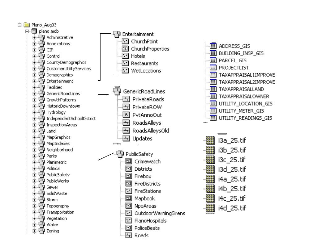
Anatomy of a GIS Database:
City of Plano
Vector Layers
Attribute Tables
Raster
Layers

27
9/28/2015 Ron Briggs, UTDallas, GIS Fundamentals
Software for GIS:
The Main Players
•
ESRI, Inc., Redlands, CA
– clear market leader with about a third of the market
– originated commercial GIS with their ArcInfo product in 1981
– privately owned by Jack Dangermond, a legend in the field
– Strong in gov., education, utilities and business logistics
•
MapInfo, Troy N.Y.
– Aggressive newcomer in early 1990s, but now well-established.
– Strong presence in business, especially site selection & marketing, and telecom
•
Intergraph (Huntsville, AL)
– origins in proprietary CAD hardware/software
– Older UNIX-based MGE (Modular GIS Environment) evolved from CAD
– Current GeoMedia was the first true MS Windows-based GIS
– strong in design, public works, and FM (facilities management), but weakening
•
Bentley Systems (Exton, PA)
– MicroStation GeoGraphics, originally developed with Intergraph, is now their exclusive and
main product..
– Strong in engineering; advertises itself as “geoengineering”
•
Autodesk (San Rafael, CA)
– Began as PC-based CAD, but now the dominant CAD supplier
– First GIS product AutoCAD Map introduced in 1996
– Primarily small business/small city customer base
The main two
“pure GIS”
companies.

28
9/28/2015 Ron Briggs, UTDallas, GIS Fundamentals
ESRI Product Line-up:
ArcGIS client products
(Fall 2007)
ArcReader (“adobe acrobat” for maps) & ArcExplorer (spatial data viewer)
–
Free viewers for geographic data.
ArcGIS 9.x Desktop:
two primary modules (MS only)
1.
ArcMap: for data display, map production, spatial analysis, data editing
2.
ArcCatalog: for data management and preview
ArcToolbox, for specialized data conversions and analyses, available as a window in both
Available capabilities within these modules are “tiered” in three levels
•
ArcView: viewing, map production, spatial analysis, basic editing:
•
ArcEditor: ArcView, plus specialized editing:
•
ArcInfo: ArcView & ArcEditor plus special analyses and conversions:
Extensions: for special apps.: Spatial Analyst, 3D Analyst, Geostatistics, Business Analyst, etc.
ArcObjects: to build specialized capabilities within ArcMap or ArcCatalog using VB for Applications
ArcGIS Workstation (for UNIX and MS)
–
the old command line ArcInfo 7.1
ArcGIS Engine (MS NT/2000/XP
)
–
Set of embeddable GIS components (ArcObjects software objects) for use in building custom
applications
–
Runs under Windows, Unix and Linux, with support for Java, C++, COM and .NET
–
Replaces MapObjects which were based upon a previous generation of GIS objects
Notes:
ArcView 3.3 the only GUI option for UNIX.
ArcGIS 8 released 2000 to integrate two previous standalone products: ArcView and ArcInfo
ArcGIS 9 released 2004 providing the full capability that should have been in ArcGIS 8!!!
--full support for all data types (coverages, shapefiles, geodatabases)
--full support for all previous geoprocessing analyses
--Modelbuilder for scripting and repetitive processing
--ArcEngine for building custom applications

29
9/28/2015 Ron Briggs, UTDallas, GIS Fundamentals
ArcGIS Server:
three tiers of capability
Data services: ArcSDE (Spatial Database Engine)
•
middleware to support spatial data storage in standard DBMS on server
•
Supports all major industry databases:
–
Oracle, SQL-Server, IBM DB2, Ingres
Map services: ArcIMS (Internet Map Server)
•
Provides maps and simple query to a user without a desktop GIS
•
Accessed via web interface
Analytic services:
•
Permits the creation of server-based specialized GIS applications
•
Provides full range of GIS capabilities to a user without a desktop GIS
•
Accessed via web interface
(prior to 9.2 these were sold as three separate products)
ArcGIS On-line Services
–
On-line services made available on the Internet with a subscription
–
Normally charged on a “per transaction” basis, but can be flat fee
–
built and operated by ESRI (or other others), usually based on ArcGIS Server
ESRI Product Line-up:
ArcGIS server products
(Fall 2007)
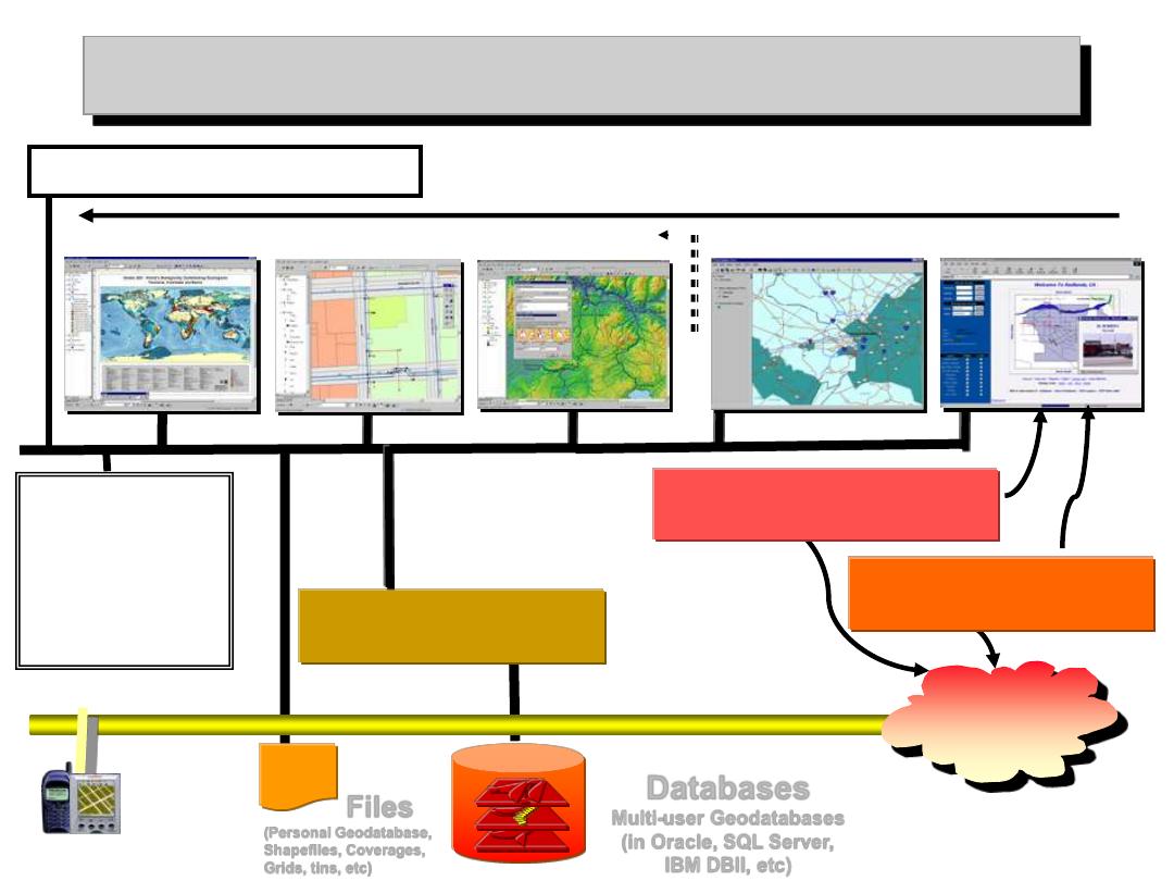
Clients
ESRI ArcGIS System
Files
(Personal Geodatabase,
Shapefiles, Coverages,
Grids, tins, etc)
ArcSDE Services
Database storage/access
Databases
Multi-user Geodatabases
(in Oracle, SQL Server,
IBM DBII, etc)
ArcInfo
ArcEditor
ArcView
ArcIMS Services
Map display & query
ArcExplorer
Browser
Internet
ArcPad
ArcEngine/
ArcObjects
Application
Development &
Customization
c:\ ArcGIS Workstation
Consistent interface
Increasing capability
ArcMap
ArcCatalog
ArcToolbox
ArcMap
ArcCatalog
ArcToolbox
ArcMap
ArcCatalog
ArcToolbox
Source: ESRI with mods.
Handheld/Wireless
$
ArcServer Services
Full GIS analysis
31
9/28/2015 Ron Briggs, UTDallas, GIS Fundamentals
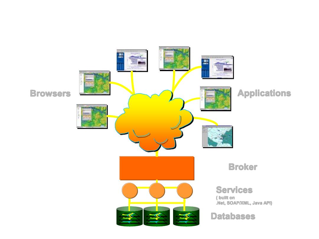
Future Generic GIS Internet Enterprise
Web Server
Databases
Broker
Browsers
Web
Applications
Services
( built on
.Net, SOAP/XML, Java API)
Source: Reza Wahadj, CSIG04, with mods
.
Dallas
Durban
Delhi