LANDFORMS AND
GEOMORPHOLOGICAL
MAPPING
1
Topography
refers to the elevation and relief of the Earth’s surface.
Landforms
are the topographic features on the Earth’s surface.
Geomorphology
is the study of earth surface processes and landforms.
2
BASIC DEFINITIONS
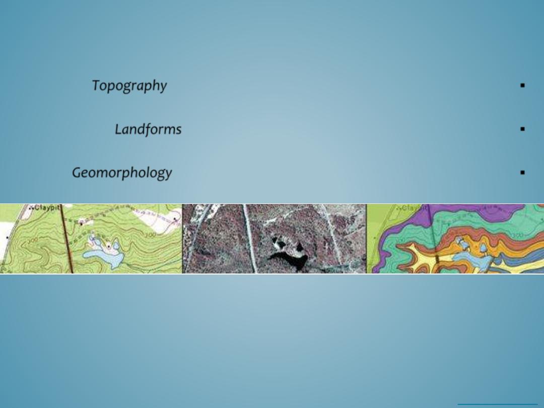
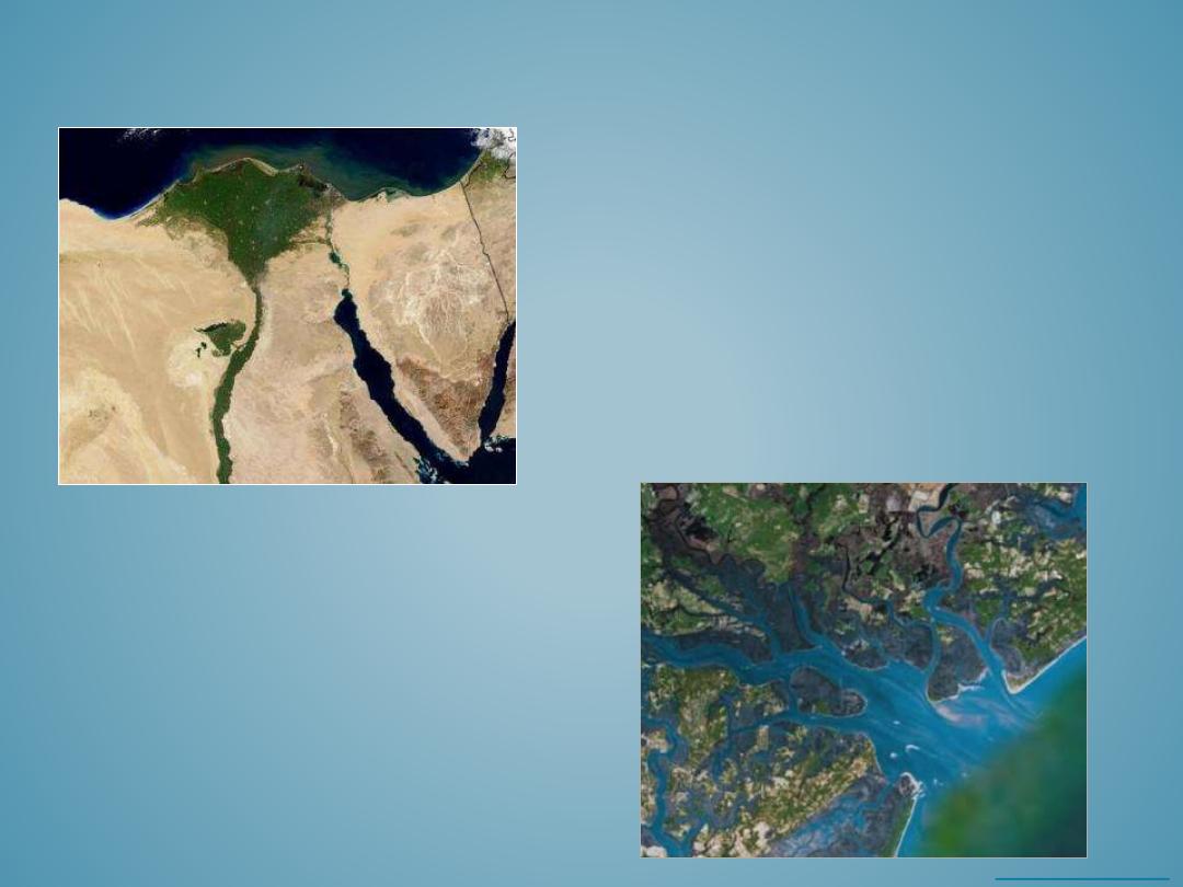
The maps above represent the same area on Earth’s surface and they show three different
ways we can view landforms. The image on the far left is a clip from a topographic elevation
map, the image in the middle is an infrared aerial photo, and the image on the right is the
geologic interpretation of surface sediments and geomorphology. This location is interesting
because it contains elements of a natural and human altered physical environment. The lake
in the image, (coded blue in the topographic and geology map, and black in the infrared
aerial photo) was formed by artificial damming a stream the flows through this landscape.

•
Landforms are the individual topographic features exposed on the Earth’s surface.
•
Landforms vary in size and shape and include features such as small creeks or sand dunes, or large
features such as the Mississippi River or Blue Ridge Mountains.
•
Landforms develop over a range of different time-scales. Some landforms develop rather quickly (over a
few seconds, minutes, or hours), such as a landslide, while others may involve many millions of years to
form, such as a mountain range.
•
Landform development can be relatively simple and involve only a few processes, or very complex and
involve a combination of multiple processes and agents.
•
Landforms are dynamic features that are continually affected by a variety of earth-surface processes
including weathering, erosion, and deposition.
•
Earth scientists who study landforms provide decision makers with information to make natural resource,
cultural management, and infrastructure decisions, that affect humans and the environment.
3
LANDFORMS
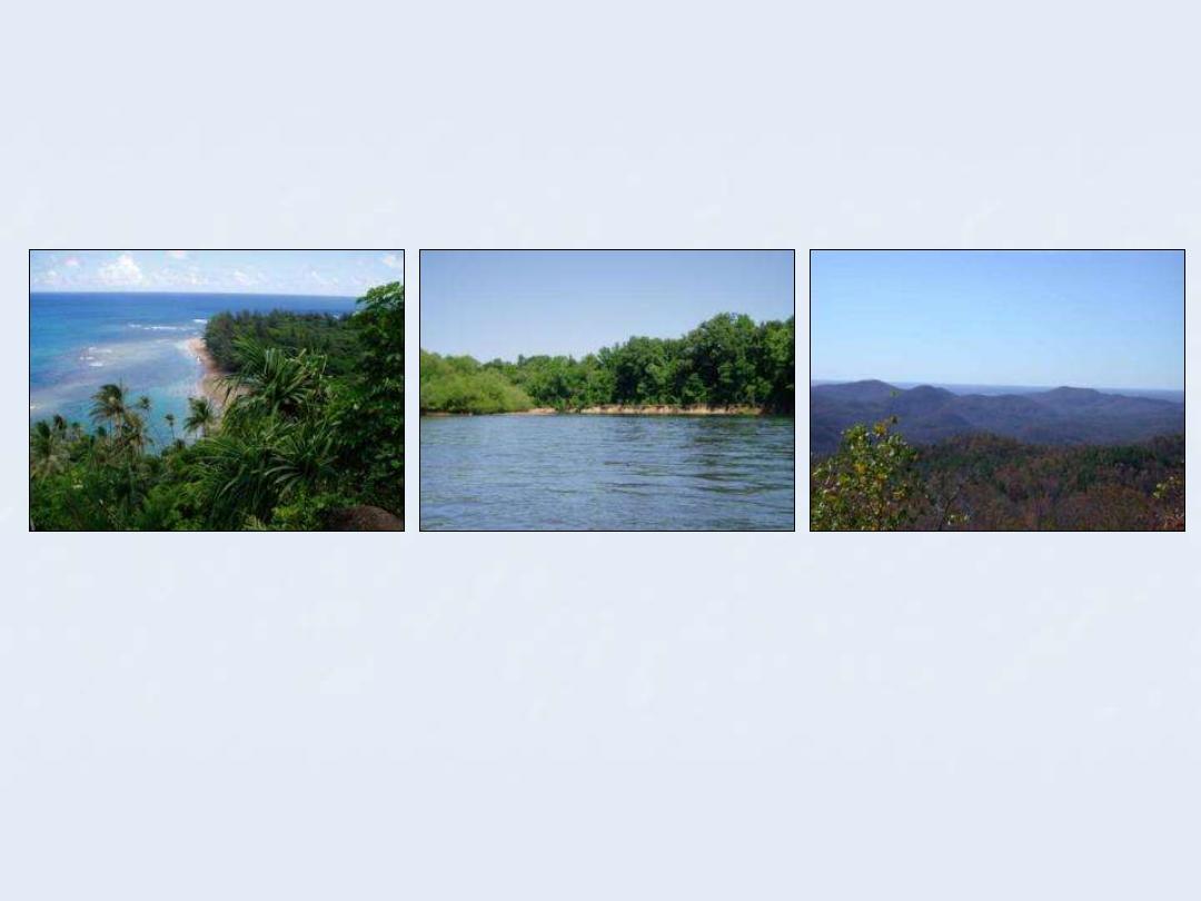
Beaches
Rivers and Flood Plains
Mountains

• Geomorphology is the process-based study of landforms.
Geo-morph-ology
originates from Greek: Geo meaning the “Earth”, morph meaning its
“shape”, and ology refers to “the study of”.
Scientists who study landforms are
Geomorphologists
.
• Geomorphology defines the processes and conditions that influence landform development,
and the physical, morphological, and structural characteristics of landforms.
• Geomorphologists who study landforms often seek to answer fundamental questions that
help them study landforms, such as:
– What is the physical form or shape of the landform?
– What is the elevation and topographic relief of the landform?
– How did the landform originate?
– What is the distribution of the landform and where else does it occur?
– Are their any patterns associated with the landform or topography?
– What is the significance of the landform in relation to other elements of the landscape
or environment?
– Has the landform or geomorphology been altered by humans?
– Does the landform or geomorphology affect humans?
5
GEOMORPHOLOGY

• Constructive processes build landforms through tectonic and depositional
processes.
– Tectonic processes
include movements at plate boundaries, earthquakes,
orogeny, deformation, and volcanic activity.
– Deposition
is the accumulation or accretion of weathered and eroded materials.
• Destructive processes break down landforms through weathering, erosion,
and mass wasting.
– Weathering
is the disintegration of rocks by mechanical, chemical, and biological
agents.
– Erosion
is the removal and transportation of weathered material by water, wind,
ice, or gravity.
– Mass wasting
is the rapid down-slope movement of materials by gravity.
6
CONSTRUCTIVE AND DESTRUCTIVE
PROCESSES
Endogenic Process
Exogenic Process
CONSTRUCTIVE PROCESSES
7
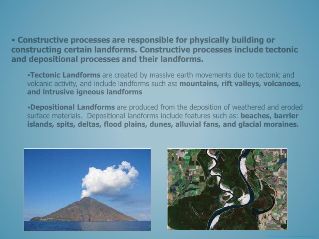
Constructive processes
are responsible for physically building or
constructing certain landforms. Constructive processes include
tectonic
and
depositional processes
and their landforms.
Tectonic Landforms
are created by massive earth movements due to tectonic and
volcanic activity, and include landforms such as:
mountains, rift valleys, volcanoes,
and intrusive igneous landforms
Depositional Landforms
are produced from the deposition of weathered and eroded
surface materials. Depositional landforms include features such as:
beaches, barrier
islands, spits, deltas, flood plains, dunes, alluvial fans, and glacial moraines.
Floodplain deposits at the confluence
of Mississippi and Arkansas Rivers.
The Stromboli Volcano erupting off the
coast of Sicily in the Mediterranean Sea.
Source: wikimedia commons
Copyright ©Google Earth 200
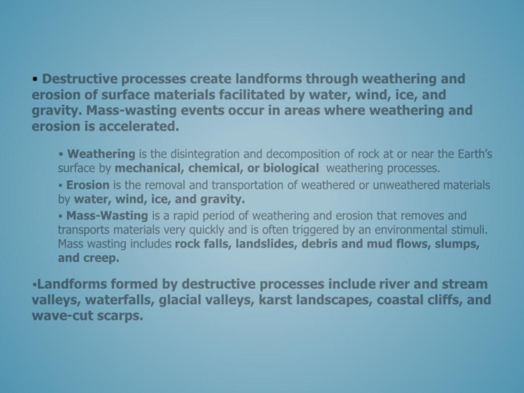
DESTRUCTIVE PROCESSES
Destructive
processes
create landforms through
weathering
and
erosion
of surface materials facilitated by water, wind, ice, and
gravity.
Mass-wasting events
occur in areas where weathering and
erosion is accelerated.
Weathering
is the disintegration and decomposition of rock at or near the Earth’s
surface by
mechanical, chemical, or biological
weathering processes.
Erosion
is the removal and transportation of weathered or unweathered materials
by
water, wind, ice, and gravity
.
Mass-Wasting
is a rapid period of weathering and erosion that removes and
transports materials very quickly and is often triggered by an environmental stimuli.
Mass wasting includes
rock falls, landslides, debris and mud flows, slumps,
and creep
.
Landforms formed by destructive processes include
river and stream
valleys, waterfalls, glacial valleys, karst landscapes, coastal cliffs, and
wave-cut scarps.

• The genetic landform classification system groups landforms by the dominant set of
geomorphic processes responsible for their formation. This includes the following
processes and associated landforms:
– Tectonic Landforms
– Volcanic Landforms
– Fluvial Landforms
– Karst Landforms
– Aeolian Landforms
– Coastal Landforms
– Glacial Landforms
• Within each of these genetic classifications, the resulting landforms are a product of
either
constructive
and
destructive processes
or a combination of both.
• Landforms are also influenced by other agents or processes including time, climate,
and human activity.
GENETIC LANDFORM CLASSIFICATION

• Tectonic landforms
• Folding
• Faulting
• Structural ridges
• Fractures
– Domes and Basins
– Horst and Graben Rift Valleys
TECTONIC LANDFORMS
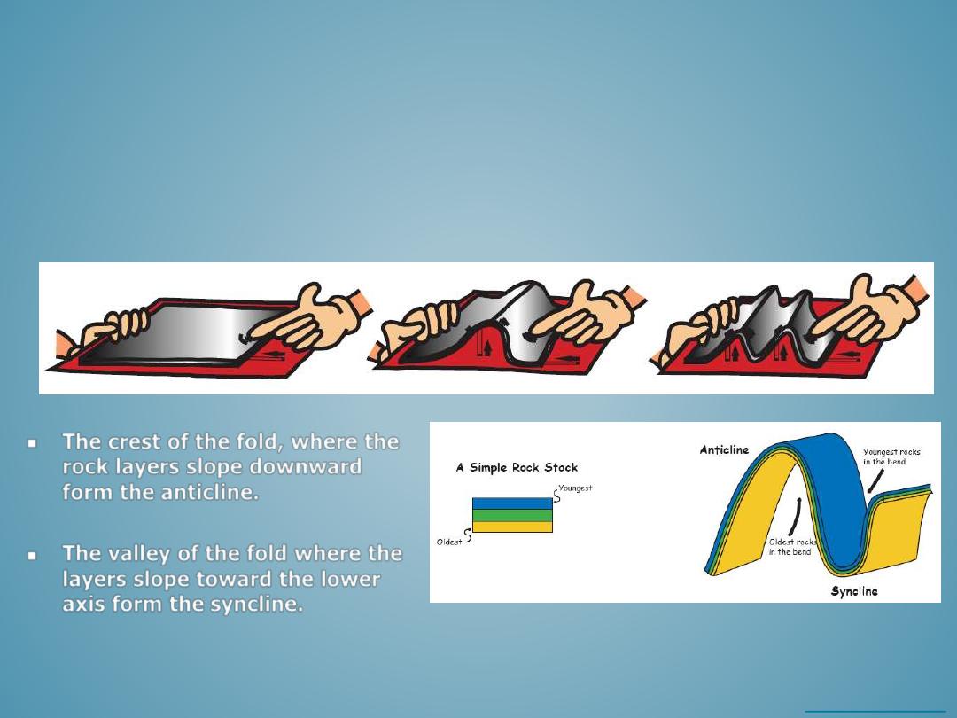
–
Folding occurs when rocks are compressed or deformed and they buckle under
the stress.
–
The diagram below is a cartoon illustrating how rocks fold.
FOLDING
The crest of the fold, where the
rock layers slope downward
form the
anticline.
The valley of the fold where the
layers slope toward the lower
axis form the
syncline.
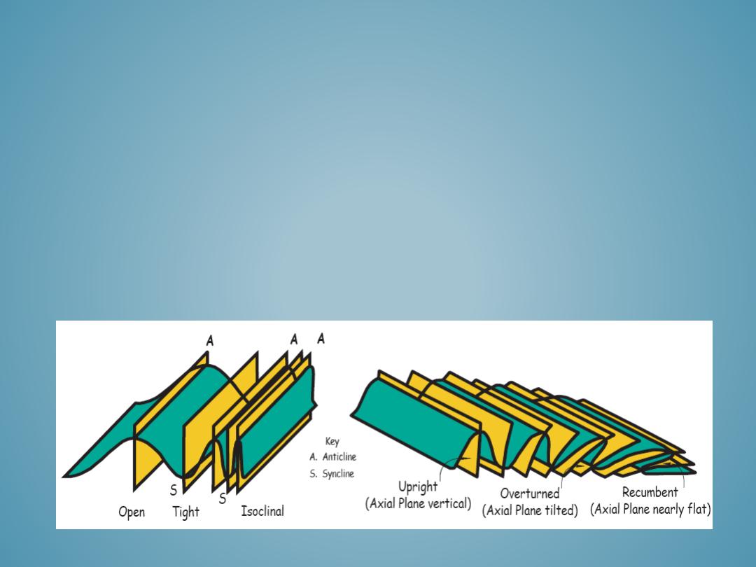
–
Anticlines and synclines can take on slightly different geometries depending on the compressional forces that
form them.
–
Very intense compressional forces form tight isoclinal folds, less intense compressional forces produce open
folds.
–
Folds can be asymmetric, upright, overturned, or curved. A fold pushed all the way over onto its side is called
recumbent.
–
Twisting or tilting during rock deformation and compression can cause folds to form at different angles.
–
Some folds are very small and can be viewed in hand held specimens, while other folds are as large as a
mountain and can be viewed from aerial photos.
12
FOLDING
13
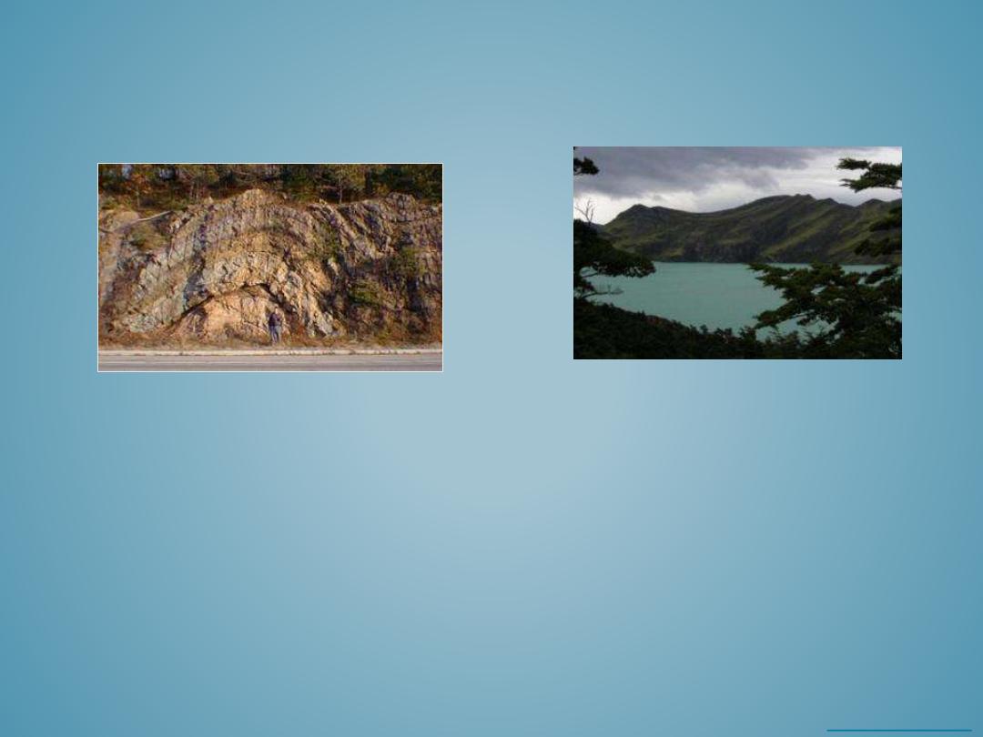
FOLDING
Anticline exposed along NJ Route 23 near
Butler NJ. The man in the bottom of the
photo helps show the scale of the folds.
Syncline valley between
mountain peaks.

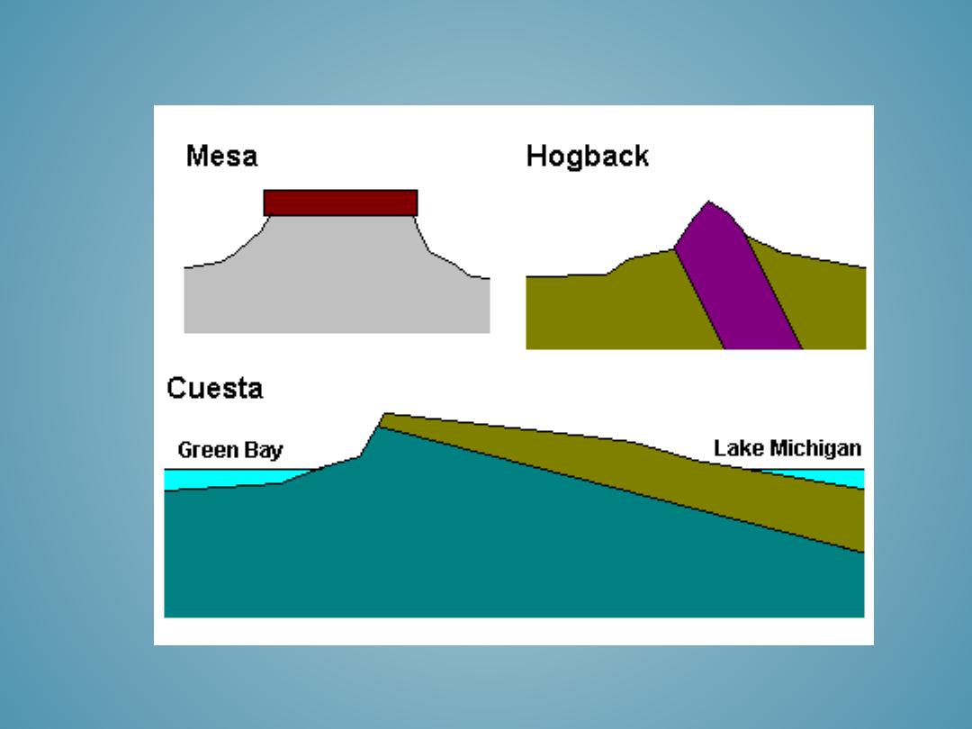
• Meza 0-5
• Cuesta 5-15
• Hogback 15-35
• Dike-like ridge <35
STRUCTURAL RIDGES
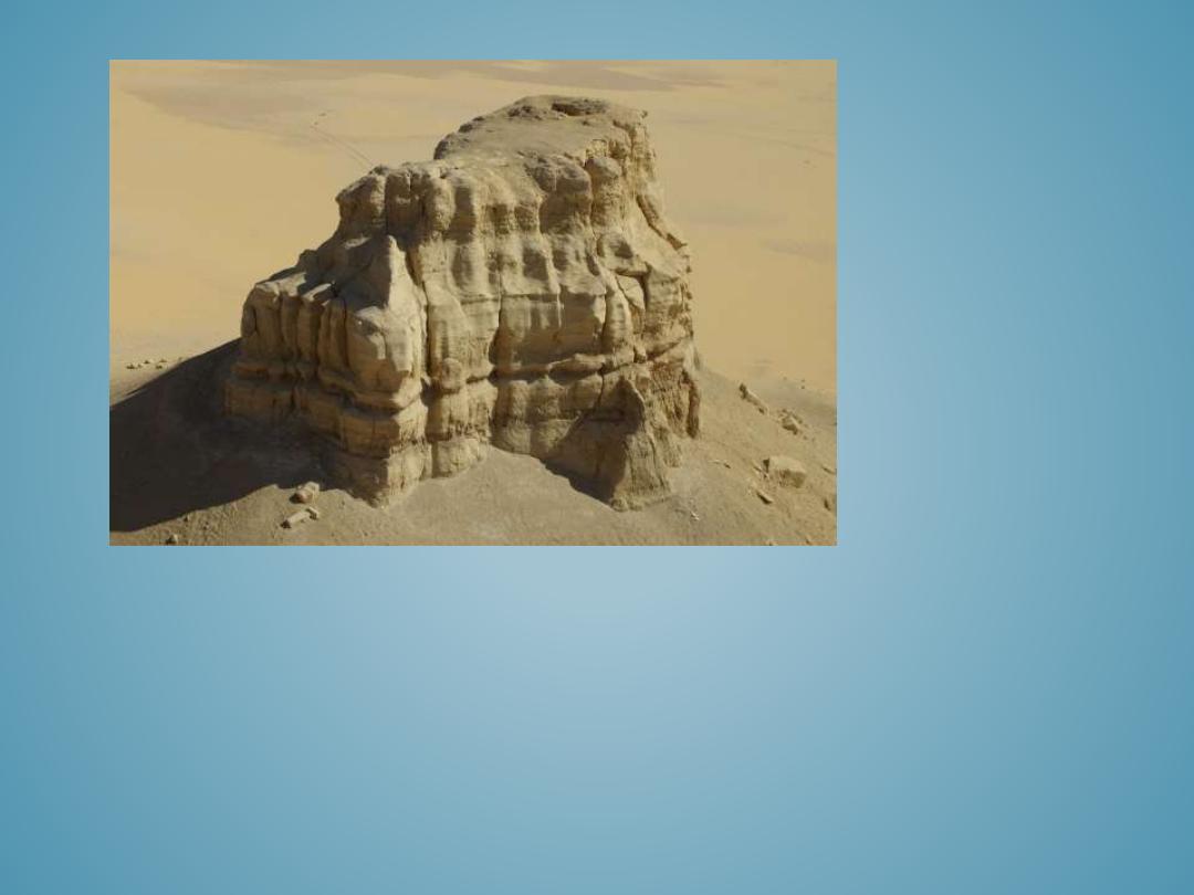
MEZA
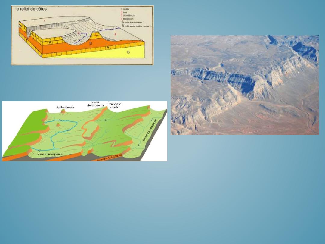
16
CUESTA
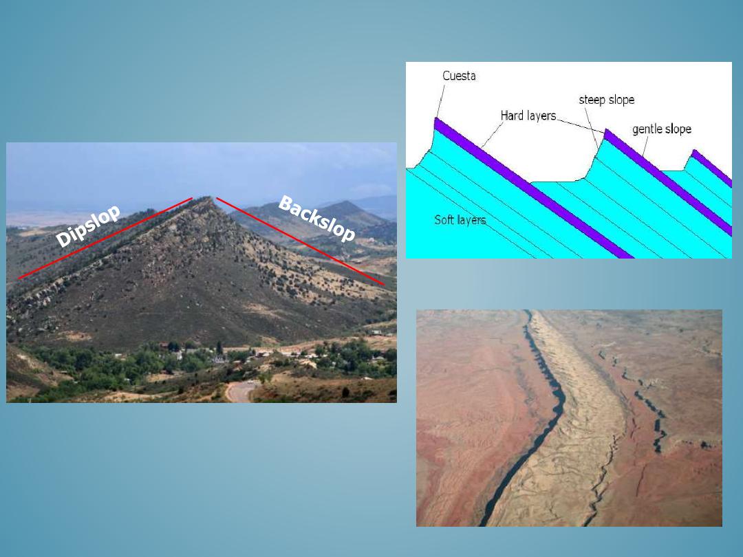
HOGBACK
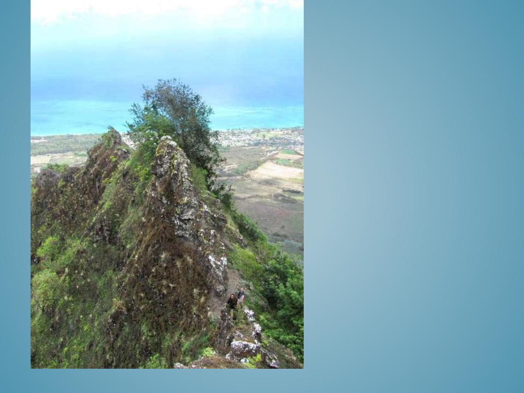
DIKE-LIKE
RIDGE
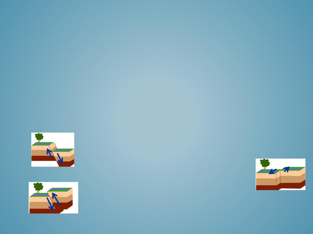
– Faulting occurs when the rocks fail under deformation processes. A fault is a planar discontinuity along
which displacement of the rocks occurs.
– There are four basic types of faulting: normal, reverse, strike-slip, and oblique
– Geologists recognize faults by looking for off-set rock layers in outcrops.
– Faults may also be recognized by debris, breccia, clay, or rock fragments that break apart or are
pulverized during the movement of the rocks along the fault plane. Fault ‘gouge’ is a term used to
describe the material produced by faulting.
– If a fault plane is exposed, there may be grooves, striations (scratches), and slickenslides (symmetrical
fractures) that show evidence of the rocks movement.
– Large fault systems, such as the San Andreas fault can be seen from aerial imagery.
FAULTING
1. Normal
: rocks above the fault plane, or hanging
wall, move down relative to the rocks below the
fault plane, or footwall.
2. Reverse
: rocks above the hanging wall moves up
relative to the footwall
3. Strike-slip
: rocks on either side of a nearly
vertical fault plane move horizontally
4. Oblique-slip
: normal or reverse faults have some
strike-slip movement, or when strike-slip faults
have normal or reverse movement
Normal
Reverse
Strike-Slip
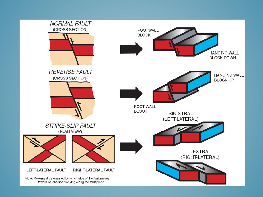
FAULTING

– Joints occur where a rock breaks but there is no displacement or faulting associated with the break. Joints
are not singular features, but they occur in sets within a given type or area of a rock.
– Fractures are breaks in rocks that are often singular more random features and are not associated with a
set of joints. Fractures often occur in association with faults or folds.
– Crustal movements, deformation, or other tectonic related movements can cause rocks to joint or fracture.
– Joints and fractures form from compression, tension, or shear stress and can range in size from millimeters
to kilometers.
– Common forms of jointing are columnar, sheet jointing, and tensional joints.
• Columnar jointing
occurs when igneous rocks cool and develop shrinkage joints along pillar-like
columns.
• Sheeting joints
occur when the layers of rock release pressure and exfoliate along parallel planes.
• Brittle fractures and tensional joints
are caused by regionally extensive compressional or elongated
pressures along folds in the crustal rocks.
– Sometimes, jointing is obvious, but the processes that caused it may be unknown, or difficult to identify.
– Fractures and joints create a variety of pathways for water to flow through, which weaken the rock and
facilitate chemical, biological, and mechanical weathering processes.
FRACTURES AND JOINTS
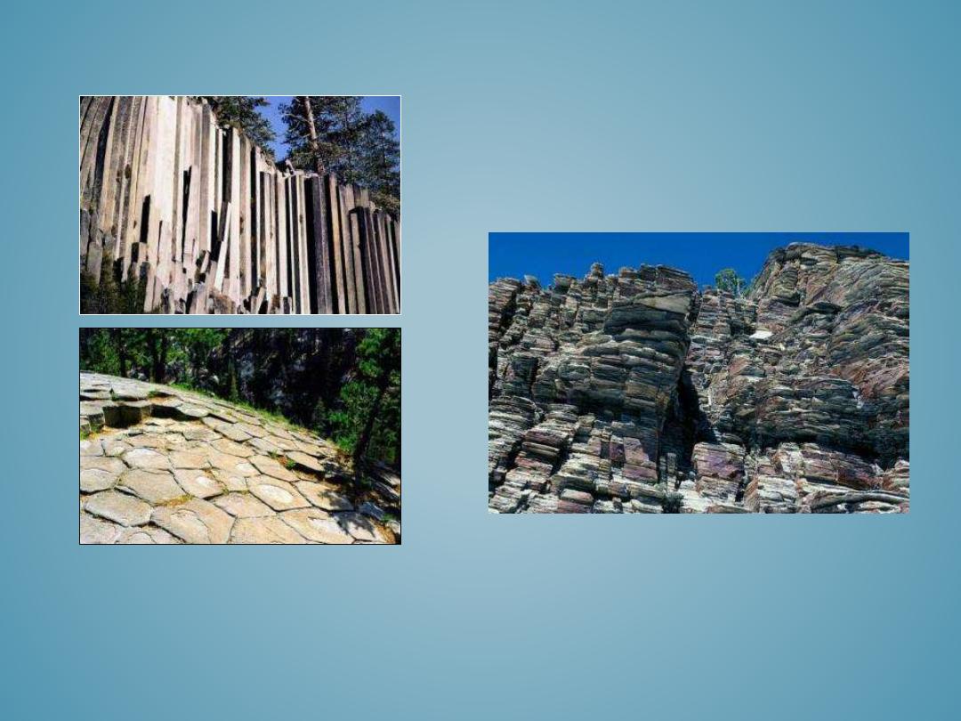
JOINTING
These two images are an example of columnar
jointing. The image on the top is a side view and
the image below is from the top. These
hexagonal columns of rock formed from cooled
basalt are part of Devil’s Postpile National
Monument in California.
The image below is of vertical jointed, bedded
meta-sandstone in the Snake Range in Nevada.
• Domes and basins are large, elongated folds formed by broad warping processes including
mantle convection, isostatic adjustment, or swelling from a hot spot.
• Upwarping produces domes, while downwarping produces basins.
• Geologists identify dome and basin structures by the stratified ages of the rock folds:
– Domes
contain strata which increase in age toward the center as the younger layers are
eroded from the top and sides.
– Basins
contain strata which is youngest toward the center and the oldest rocks form
the flanks or sides.
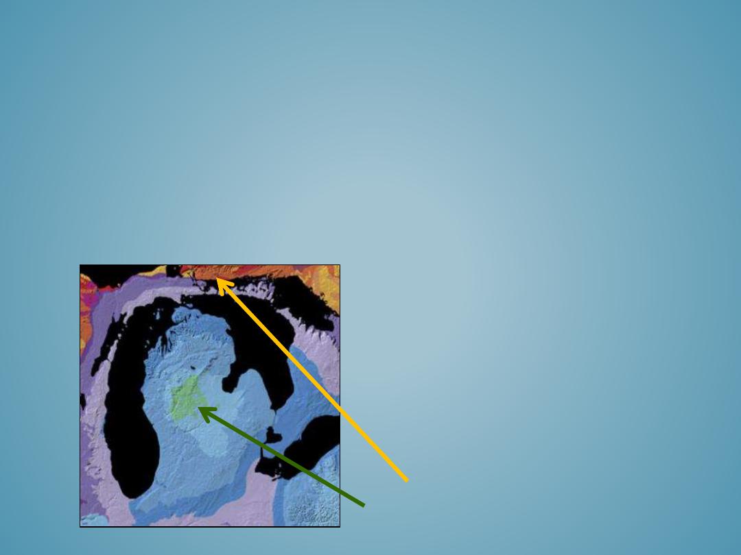
DOMES AND BASINS
This geologic map of the Michigan Basin
illustrates the circular pattern of the
sedimentary strata. The green color in the
center of the map represents the youngest
rocks which are Upper Pennsylvanian; and
the rocks progressively increase in age
toward the periphery where the reddish-
orange colors represent the oldest rocks
flanking this structure which are
Ordovician and Cambrian age.
Youngest rocks (Upper Pennsylvanian)
Oldest Rocks (Ordivician and Cambrian)
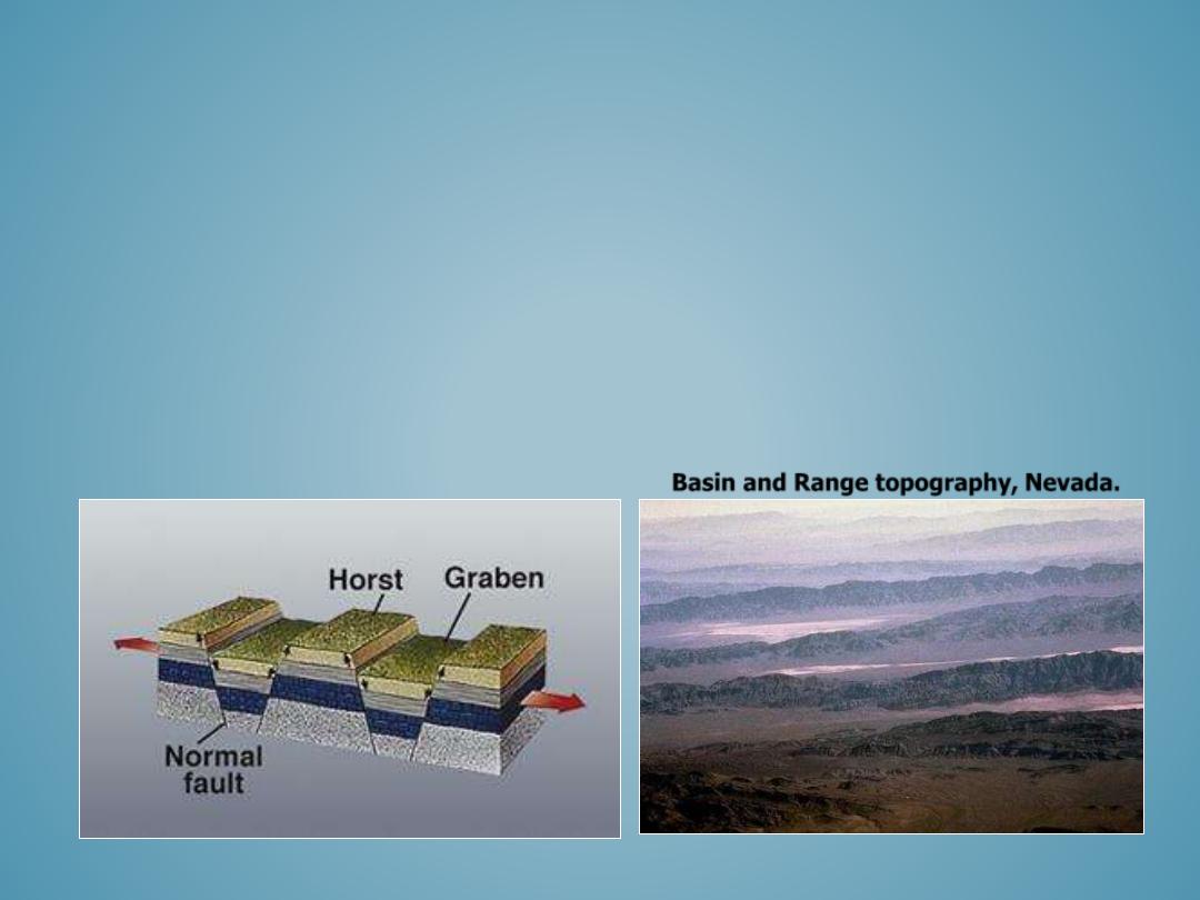
• Horst and graben topography is generated by normal faulting associated with crustal extension.
• The central block termed graben is bounded by normal faults and the graben drops as the crust
separates.
• The graben forms an elongated valley that is bound by uplifted ridge-like mountainous
structures referred to as horsts.
• Some horsts may tilt slightly producing asymmetric, tilted terrane or mountain ranges.
• In the Western United States, horst and graben fault sequences are described as “Basin and
Range” topography.
HORST AND GRABEN:
BASIN AND RANGE
Basin and Range topography, Nevada.
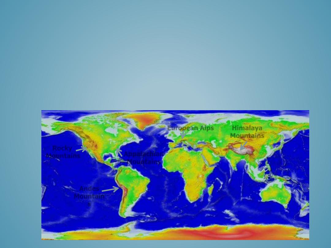
• Antarctica: Antarctic Peninsula, Transantarctic Mountains
• Africa: Atlas, Eastern African Highlands, Ethiopian Highlands
• Asian: Himalayas, Taurus, Elburz, Japanese Mountains
• Australia: MacDonnell Mountains
• Europe: Pyrenees, Alps, Carpathians, Apennines, Urals, Balkan Mountains
• North American: Appalachians, Sierra Nevada, Rocky Mountains, Laurentides
• South American: Andes, Brazilian Highlands
MAJOR MOUNTAIN RANGES OF
THE WORLD
Rocky
Mountains
Andes
Mountain
s
Appalachian
Mountains
Himalaya
Mountains
European Alps
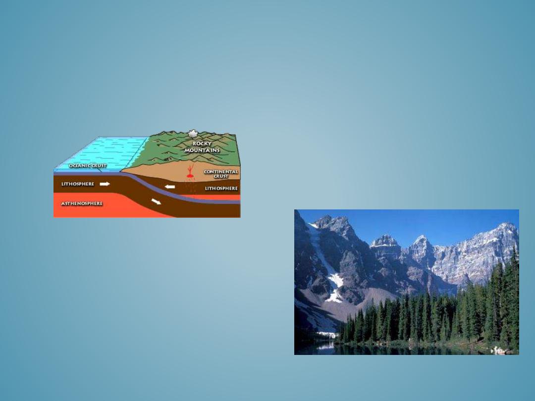
•
The Rocky Mountains, which extend from British Columbia to Texas were formed by the Laramide Orogeny
40-80 million years ago; however, there is still active uplift today.
•
Colorado’s Front Range, the Sangre de Cristo Mountains of Colorado and New Mexico, the Franklin Mountains
in Texas, and Wyoming’s Bighorn Mountains are all part of the “Rocky Mountain Range”.
ROCKY MOUNTAINS
The Laramide Orogeny was characterized by intense
tectonic activity resulting from a series of compressional
and extensional events. The subduction of the Pacific
Ocean Plate caused compressional forces in the continental
plate, and pushed the oceanic plate downward. Following
subduction of the oceanic plate, upwelling and extensional
forces caused the literal uplift of the continental bedrock
and formed of the Rocky Mountains. The lower crust in this
region of upwelling and uplifting is relatively thin and
stretches under pressure. The upper crust is very brittle and
deforms easily. As a result the upper crust is characterized
by large angular tilted faults blocks which form the Rocky
Mountains we see today.
Source: USGS
The Rocky Mountains contain some of the most
beautiful scenery in North America and are home
to hundreds of parks and recreational areas
including Rocky Mountain National Park,
Yosemite National Park, Glacier National Park,
and Grand Tetons National Park.
• Cinder Cones
• Shield Volcanoes
• Strato (Composite)Volcanoes
• Lava Domes
• Caldera
• Volcanic Necks
• Volcanic Hot-Spots
VOLCANIC LANDFORMS
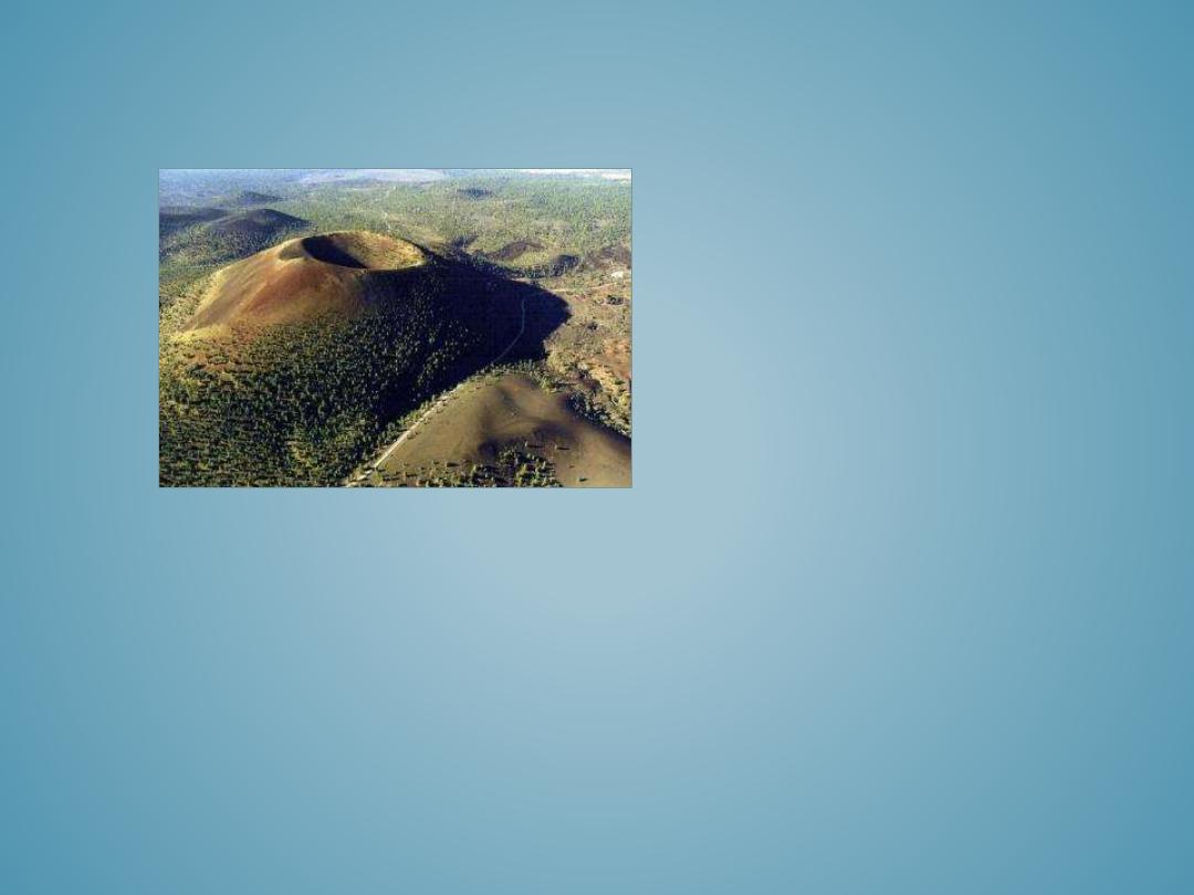
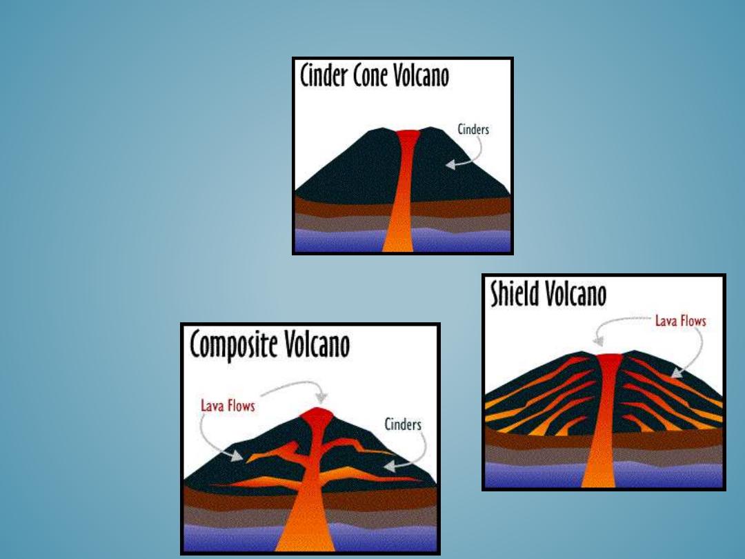
CINDER CONES
Cinder cones have an easily
recognizable hill shape form with
relatively steep 30-40 degree
slopes. This angle represents the
steepest angle maintained by
unconsolidated, loose material and
is commonly referred to as the
angle of repose. This image is of
an older cinder cone with small
caldera depression on the summit.
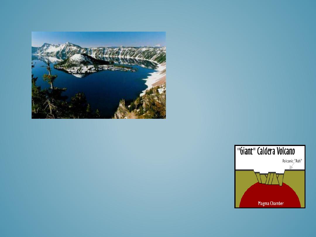
CALDERA
Crater Lake in Oregon is
the collapsed caldera of
Mount Mazama and is now
filled in with water.
Wizard Island is a volcanic
cone in the middle of the
lake. Crater Lake is the
deepest lake in the United
States at 1,932 feet deep!
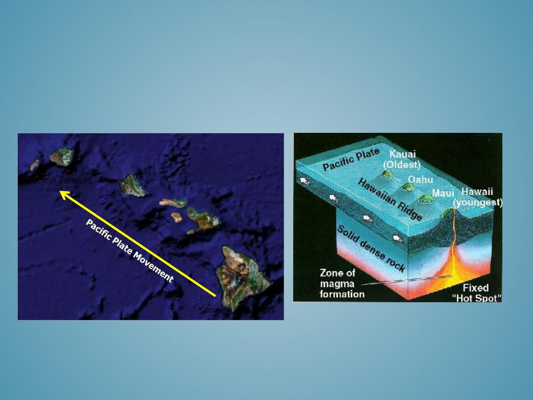
VOLCANIC HOT SPOTS
Kauai
Oahu
Maui
Hawaii
Kahoolawe
Lanai
Molokai
Nihau
Oldest Islands
Youngest Islands
• River Systems and Fluvial Landforms
• Longitudinal Profile and Watersheds
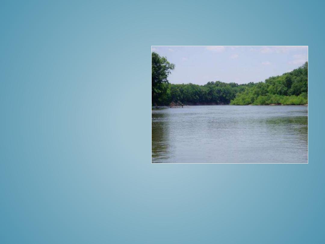
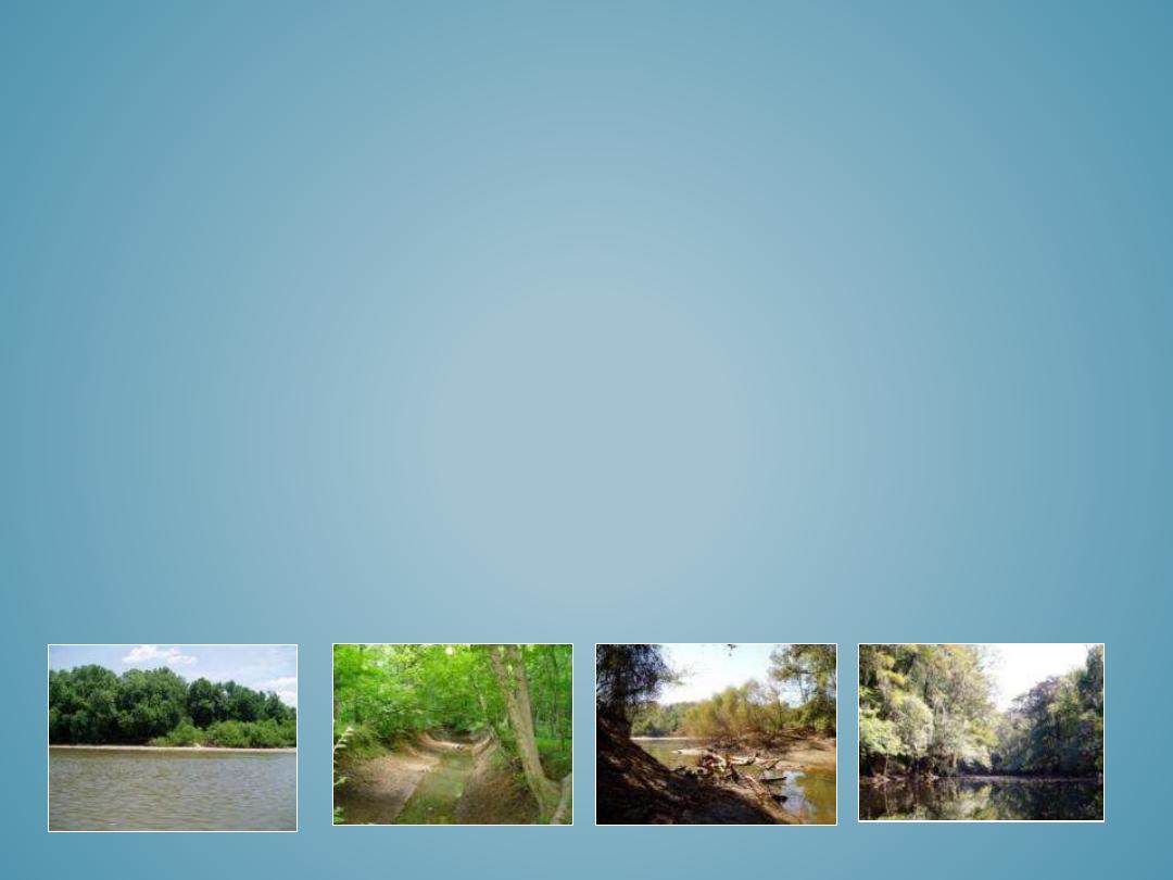
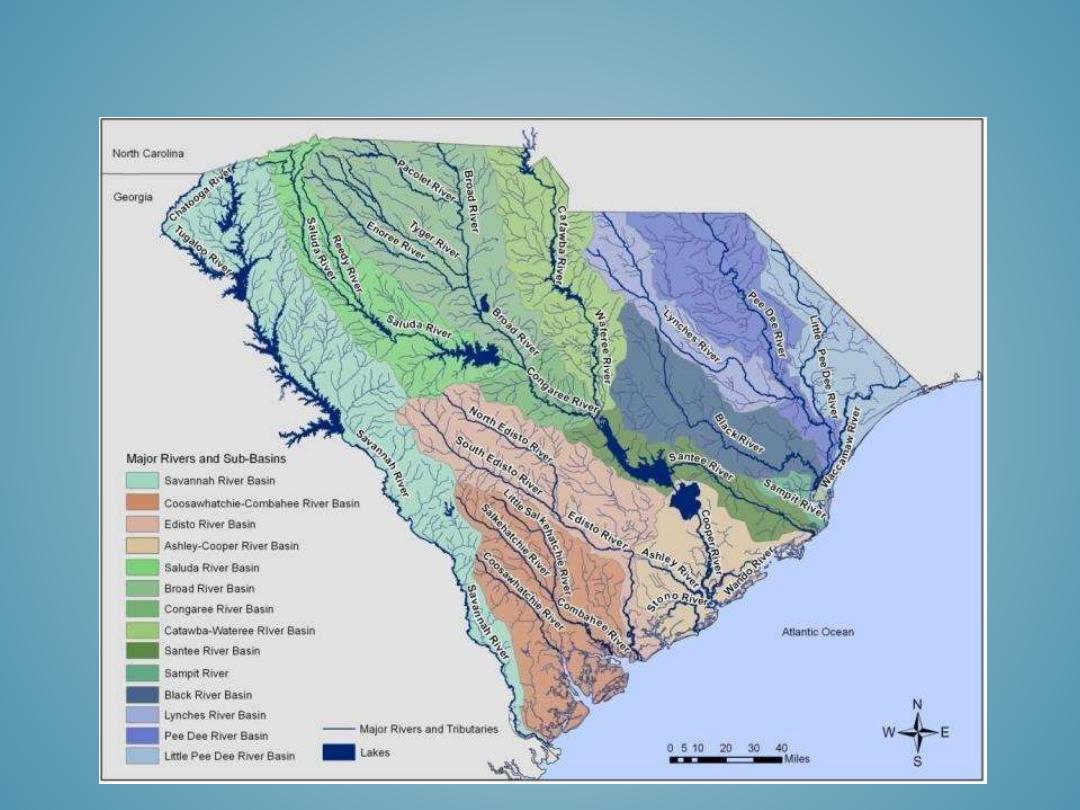
• South Carolina Rivers
• Lakes and Dams
• Mountain Streams
• Straight Rivers
• Braided Rivers
• Meandering Rivers
• Anabranching Rivers
• Gulleys
• River Terraces
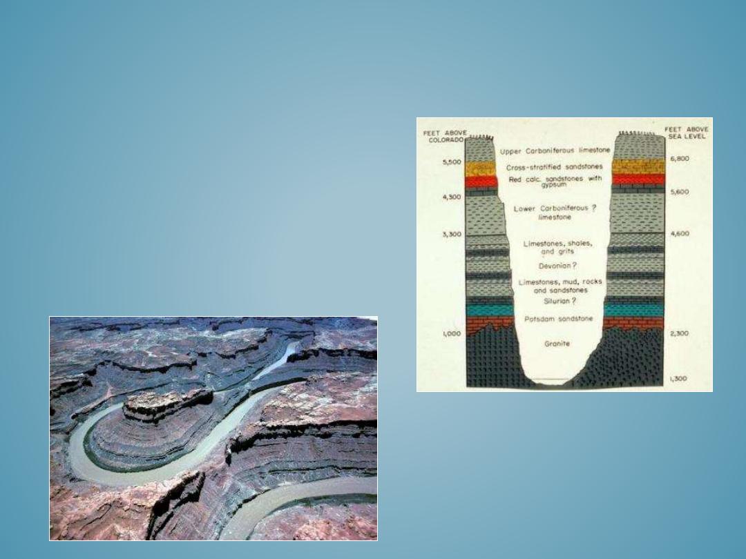
• River Canyons
• Waterfalls
• Flood plains
• Alluvial Fans
FLUVIAL LANDFORMS
•
Rivers are one of the most dominant agents of landscape change because their flowing waters are continually
eroding, transporting, and depositing sediments.
•
Rivers are critically important to people because they provide fresh drinking water, transportation of people,
goods, and wastes, hydro-electric power generation, irrigation, and recreation.
•
Rivers, although very important to people, are also very dangerous because flooding is among one of the most
frequent and widespread natural hazards that can damage or destroy land, property, and life.
•
Because rivers systems are so important to humans, it is necessary for scientists to understand how rivers
affect the landscape and also how humans affects rivers. Having this information enables people to better
manage for future water resource needs and prevent hazardous situations.
RIVER SYSTEMS AND FLUVIAL
PROCESSES

•
The
longitudinal profile
of a river is an elevation cross-section of the entire watershed from the source of
flowing water to the mouth of the stream.
– The source area of flowing water is defined as the
headwaters
. Headwaters are the highest elevation
where water collects to form a stream network and is generally formed by either snow-melt runoff, a
natural spring, or rainwater.
– The mouth of the stream is typically defined by the stream’s ultimate
base level
, and this generally
corresponds with the sea level where the river meets the ocean. Base level is the lowest elevation that a
stream can erode its channel. Local or temporary base levels may be formed by reservoirs or waterfalls.
– A river’s gradient (slope) is steepest near the headwaters and gentlest near the mouth.
– As rivers flow from their headwaters to their base level they carve valleys into the landscape by
eroding, transporting, and depositing weathered rocks, soil, and sediment.
•
A
watershed
or
basin
is the area of land bound by a local elevation ridge, referred to as a
drainage divide
,
where all the water within that area drains downstream from its headwaters to a single outflow location. A
watershed can include an entire river system from it headwaters to ultimate base level, or smaller watersheds
can encompass tributary sub-basins that are part of the larger watershed.
•
Drainage divides are high elevation ridges that separate one watershed from another.
LONGITUDINAL PROFILE AND
WATERSHEDS
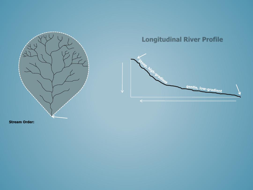
LONGITUDINAL PROFILE AND
WATERSHEDS
Longitudinal River Profile
E
le
va
tio
n
(f
ee
t)
0
3,000
Headwaters
Ultimate
Base level
River Length (Miles)
100
0
This diagram outlines the longitudinal profile of a
river basin from the headwaters to the ultimate
base level, or sea level. A rivers gradient is
steepest near the headwaters and gentlest near
the base level. In South Carolina, the steepest
sections are often found in the blue Ridge and
Piedmont, while the gentler gradient occurs in the
Coastal Plain. River length, or distance, is
measured from the rivers mouth to its headwaters,
seemingly reversed from what one might expect.
Headwaters:
multiple low-order
streams near
drainage divide
Base level:
single outflow and
highest order
stream
1
1
1
2
2
1
1
3
4
3
4
5
This figure is a hypothetical river basin. The black
dotted line represents the drainage divide and the
numbers refer to stream order. Any rainfall that falls
within the black dotted line will eventually flow into the
main stem river and out at the mouth. Stream order
increases from the headwaters to the base level. In this
example, the river is a5
th
-order river.
Stream Order:
1
st
order and 1
st
order = 2
nd
order
2
nd
order and 2
nd
order = 3
rd
order
3
rd
order and 3
rd
order = 4
th
order
4
th
order and 4
th
order = 5
th
order
And so on, 5 and 5 =6, 6 and 6 =7
th
order…
5
RIVERS AND BASINS
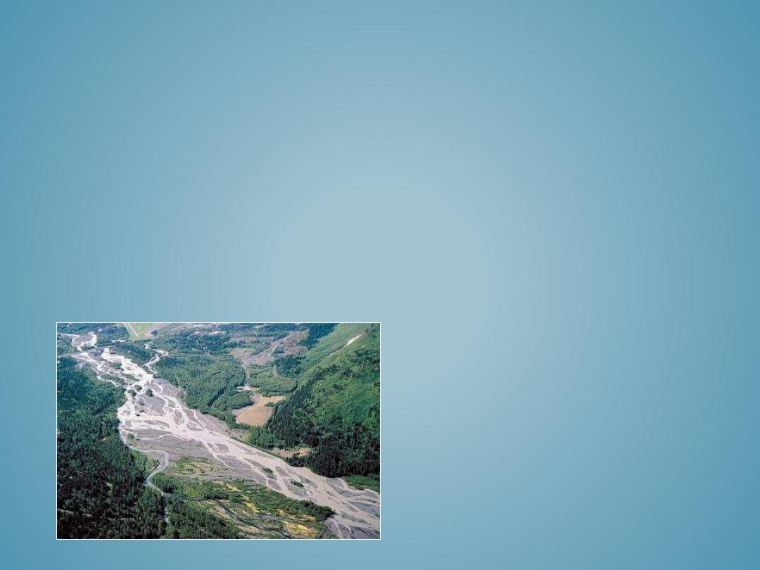
BRAIDED
• Braided river patterns occur in high-energy environments that contain an excessive sediment
load that is deposited on the bed of the channel. The stream loses the capacity to transport the
sediments and it forces its way through the accumulation of sediments forming an interwoven
network of channels.
• The islands between the braided channels are ephemeral and dynamic. The sediment is
continually remobilized, transported and deposited, leaving minimal time for vegetation to
establish, as a result they are rarely vegetated.
• Braided channels tend to be wide and shallow with defined banks that are higher than the mid-
channel islands.
• Braided channels occur downstream of areas with high sediment loads. Their sediment textures
vary from silts, sands, and gravels depending on the sediment source.
Copyright © Marli Miller, University of Oregon
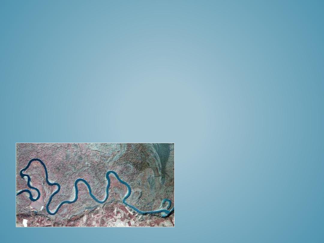
MEANDERING
• Meandering river patterns are low-gradient, sinuous channels that contain multiple, individual
meander bends that are laterally migrating across the flood plain.
• As they migrate or move across the flood plain they are continuously eroding, transporting, and
depositing alluvial sediments.
• Meandering rivers and their hydrologic conditions create a variety of depositional and erosional
landform features that collectively form the flood plain valley.
• The primary features of meandering channels are the aggrading pointbar deposit on the inside
of a meander bend and eroding cut bank along the outside of the bend. As the channel
migrates laterally across the flood plain, sediments are eroded from the outer cutbank and
deposited on the inner pointbar.
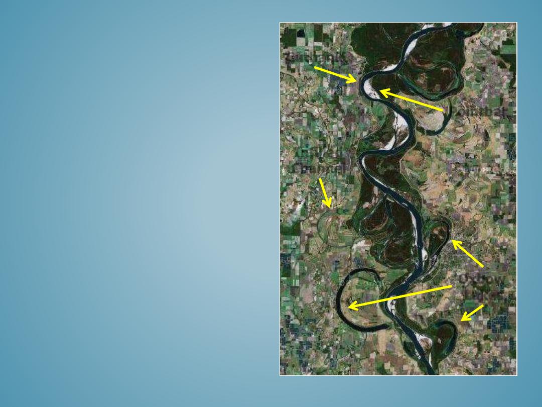
• Occasionally, meandering channels cut-off entire meander bends; these cut-offs are
incorporated into the flood plain as oxbow lakes or in-filled channels.
2006 Aerial imagery: http://www.dnr.sc.gov/GIS/gisdata.html
Cliffs or escarpment
• Flood plains are the landform adjacent to the
river channel that is influenced by modern river
processes. Flood plains are constructive,
depositional landforms created by stream flow
and sediment deposition.
• Flood plain environments are composed of a
mosaic of different landform features including
cutbanks
,
pointbars
,
natural levees
,
crevasse
channels
and
crevasse splays
,
infilled channels
and
oxbow lakes
,
backswamps
, and
occasionally yazoo tributaries and other flood
plain channels.
FLOOD PLAINS
Copyright ©2008 Google
Pointbar
Cutbank
Oxbow
Lakes
Infilled
Channel
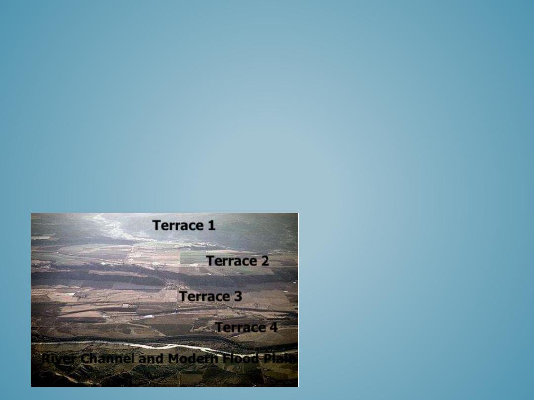
• River terraces are older remnant flood plain surfaces that are higher in elevation than the
modern flood plain. They may occur on one or both sides of the valley.
• Terraces are formed when the river channel cuts down into the flood plain and laterally erodes
the alluvial valley, carving a new river channel and flood plain entrenched within the older flood
plain surfaces. Down cutting can occur because of hydrologic or sedimentary changes in the
headwaters or valley gradient changes caused by a retreating sea-level and lowered or extended
base-level. Terraces can also form from tectonics and valley uplifting.
• Terraces are generally isolated from the more recent river processes and may only flood during
100 or 500 year flood events. River terraces are often archeological hot spots because they
contain artifacts from historic colonies that used the river and flood plain.
RIVER TERRACES
Copyright©Louis Maher, University of Wisconsin
Terrace 1
Terrace 2
Terrace 3
River Channel and Modern Flood Plain
Terrace 4
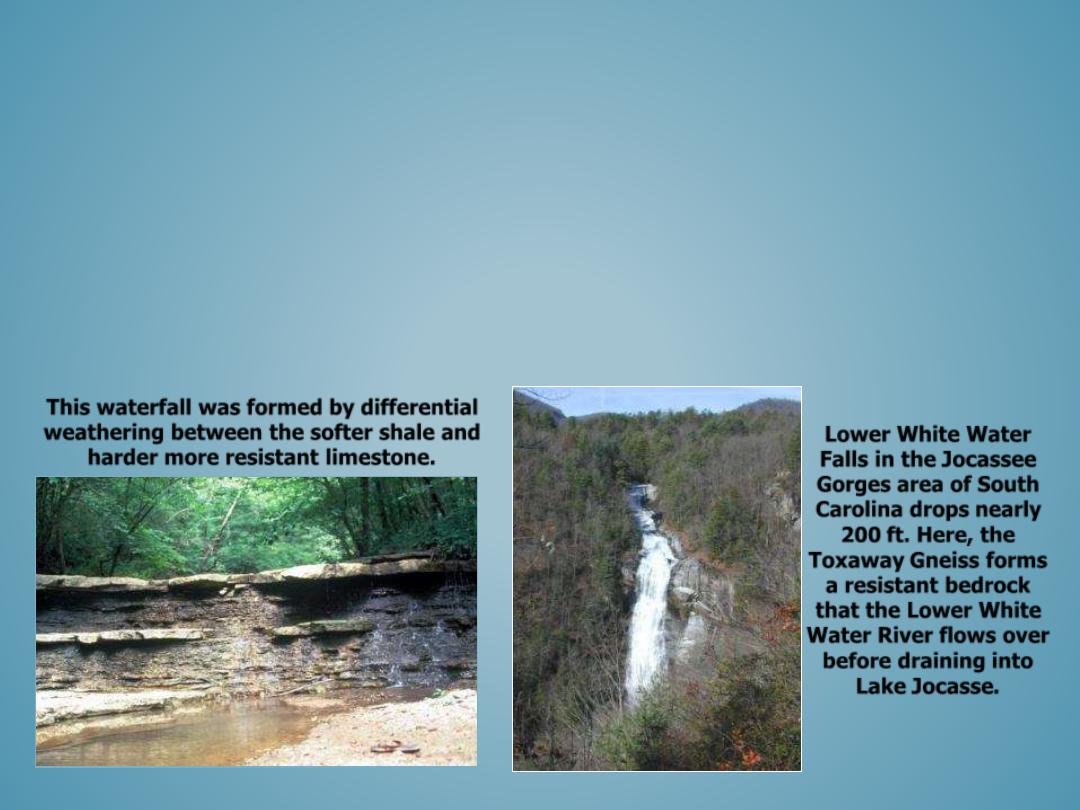
•
Waterfalls occur where there is resistant bedrock, abrupt changes in bedrock resistance, or along fractures
or faults in the bedrock.
•
Less resistant materials are weathered more quickly than resistant rocks, creating stair-stepped ledges or
drop offs where waterfalls occur. Less resistant rocks may also form pools between resistant rocks that
form waterfalls.
•
Faults and fractures often provide natural pathways for the downslope movement of water.
•
The location of the waterfalls origin may be referred to as a “knick-point”, continued weathering by the
stream flow causes the knick-point to slowly migrate upstream.
•
Most waterfalls in South Carolina occur along streams in the Blue Ridge, Piedmont, and the along the
Regional Fall Line where there are rock layers of varying resistance.
WATERFALLS
This waterfall was formed by differential
weathering between the softer shale and
harder more resistant limestone.
Lower White Water
Falls in the Jocassee
Gorges area of South
Carolina drops nearly
200 ft. Here, the
Toxaway Gneiss forms
a resistant bedrock
that the Lower White
Water River flows over
before draining into
Lake Jocasse.
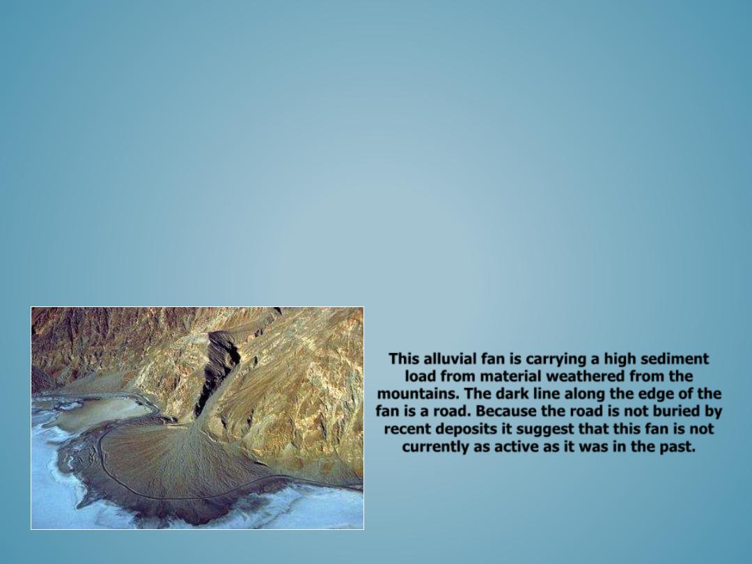
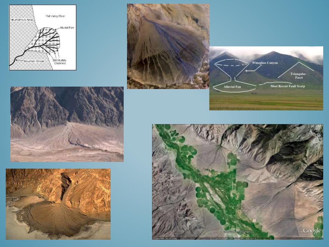
• Alluvial fans are fan-shaped fluvial deposits that accumulate at the base of stream
where it flows out from a steep gradient and enters into a lower-gradient flood
plain or valley setting.
• The stream enters the valley carrying a higher capacity sediment load than it can
continue to carry, and as a result it deposits the sediments as an alluvial fan.
• Alluvial fans generally form in arid environments with a high sediment load and
where there is minimal vegetation to disrupt the fan formation.
• Alluvial fans may form from a single high-flow event or from the accumulation of
multiple events.
ALLUVIAL FANS
Copyright © Marli Miller, University of Oregon
This alluvial fan is carrying a high sediment
load from material weathered from the
mountains. The dark line along the edge of the
fan is a road. Because the road is not buried by
recent deposits it suggest that this fan is not
currently as active as it was in the past.
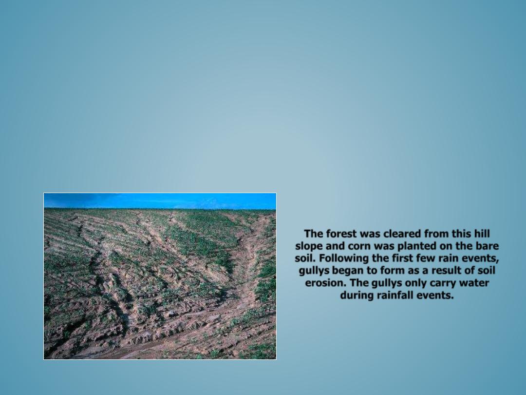
GULLYS
– Gullys are formed by hillslope erosion.
– Rainwater runoff draining over the surface of a hillslope generates erosive
overland flows that remove weathered rocks and soil.
– When multiple gullys form they produce a disconnected network of headwater
channels that dissect the hillslope and increase soil erosion.
– Gullys primarily form on disturbed hillslopes where forest and vegetation have
been cleared.
The forest was cleared from this hill
slope and corn was planted on the bare
soil. Following the first few rain events,
gullys began to form as a result of soil
erosion. The gullys only carry water
during rainfall events.
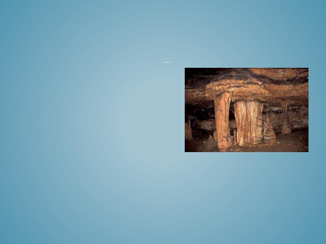
• Caverns
• Sinkholes
• Disappearing Streams
• Springs
• Towers
KARST LANDFORMS
Karst is a term used to describe landscapes that are formed by chemical weathering
process controlled by groundwater activity. Karst landscapes are predominantly
composed of limestone rock that contains > 70 percent calcium carbonate.
Copyright© Oklahoma University
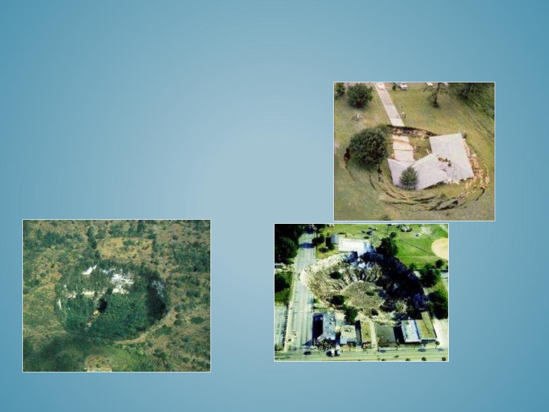
SINKHOLES
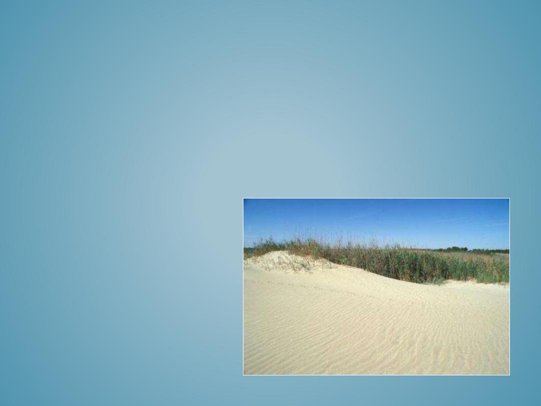
•
Dunes
•
Loess Formations
•
Carolina Bays
AEOLIAN LANDFORMS
Aeolian landforms are formed by the deposition of windblown sediments. The sediments
are generally sourced from deserts, glacial deposits, rivers, or coastal shorelines. Aeolian
sediments are often composed of well-rounded, sand-to silt-sized particles, that are
weathered by wind abrasion during transport. Sediments are deposited when the
velocity of the wind falls and there is not enough energy available to entrain and
transport the sediments. Sands will begin to accumulate wherever they are deposited
and often continue to move along the ground.
•
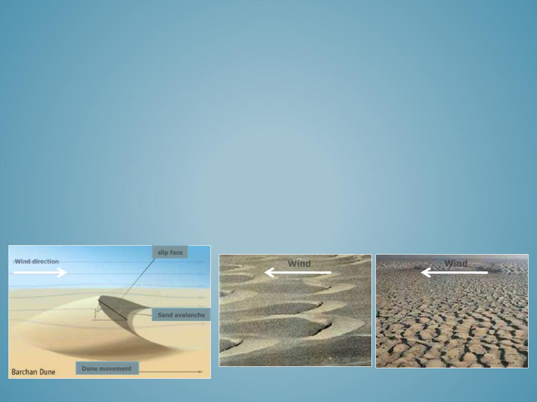
Barchan dunes
are solitary, crescent shaped dunes with their tips pointing downwind. They form where sand
source is limited, wind direction is constant, and the ground is void of vegetation. They can reach heights of
30 meters and spread nearly 300 meters.
•
Transverse dunes
are a series of long ridges that are parallel to one another, and are perpendicular to the
prevailing wind. They form in areas where the prevailing winds are steady, there is an abundant supply of
sand, and vegetation is sparse. They can reach heights of 200 meters and may extend for 100’s of kilometers.
DUNES
Barchan Dunes
Wind
Transverse Dunes
Wind
Wind direction
slip face
Sand avalanche
Dune movement
• Littoral Zone
• Beaches
• Barrier Islands
• Beach Ridges
• Spits
• Deltas
• Coastal Cliffs
• Marine Terraces
• Wave-Cut Scarps
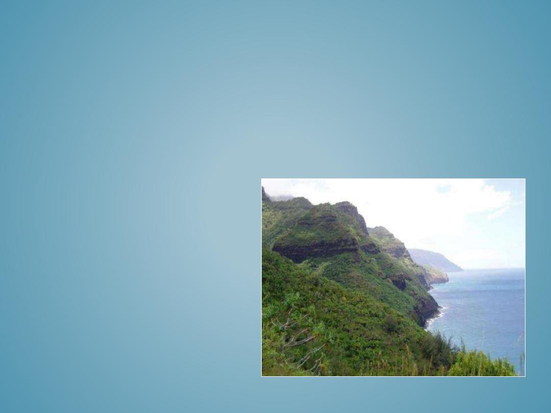
COASTAL LANDFORMS
Hawaiian coastline
Coastal landforms include a diverse array of shoreline and near-shoreline
features, as well as some coastal plain landforms far removed from the modern
ocean by long term sea-level changes. This section will explore both constructive
and destructive landforms formed by current coastal processes, as well as
marine related landforms that were formed during periods of higher sea level.
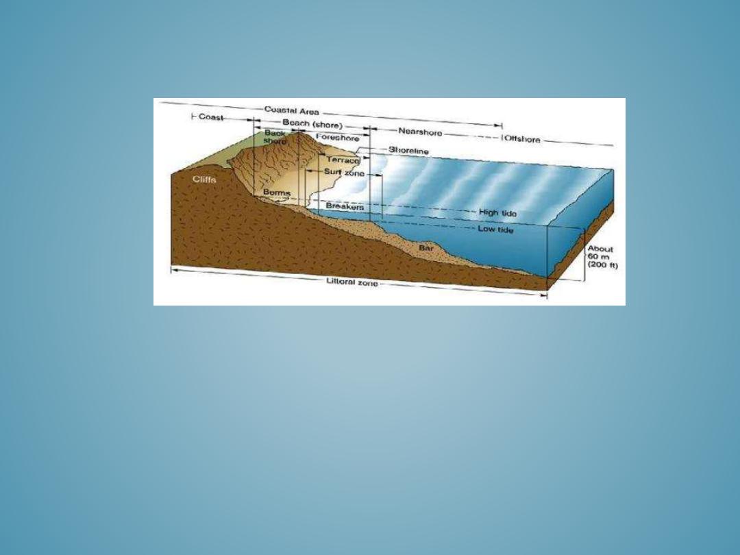
Littoral Zone
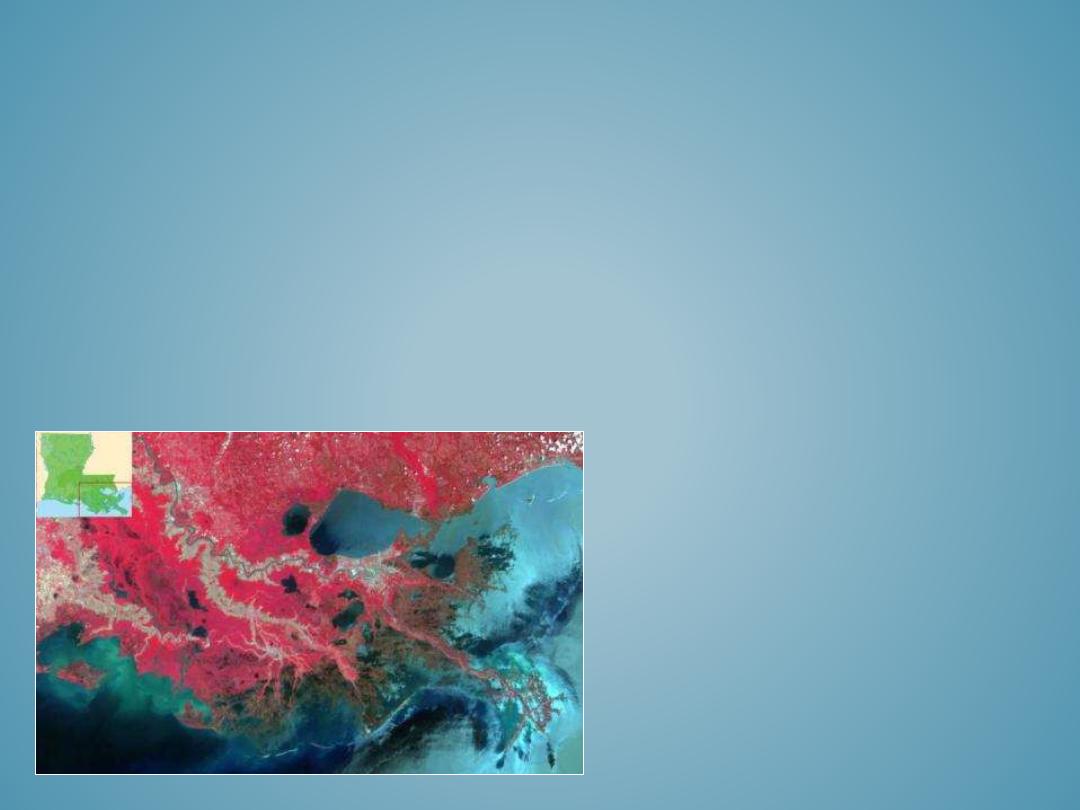
DELTAS
Deltas form where the mouth of a river meets its ultimate base level at the ocean or
sea. As the river’s velocity decreases, it looses the capacity to carry its sediment load
and the resulting deposits form a delta. Delta shapes and forms vary depending on
tidal influences, waves, currents, sediment type and quantity, river discharge, and the
stream gradient near the outlet. The most common types of deltas include bird-foot,
estuarine, and arcuate.
Not all rivers form deltas, for example the Amazon deposits its sediment load directly
into the ocean onto an underwater seaward sloping continental shelf. The Columbia
River in the northwest United States, lacks a delta altogether, because the currents
are too strong and erosive for the sediments to deposit.
Mississippi River Delta: Bird-Foot Delta
•
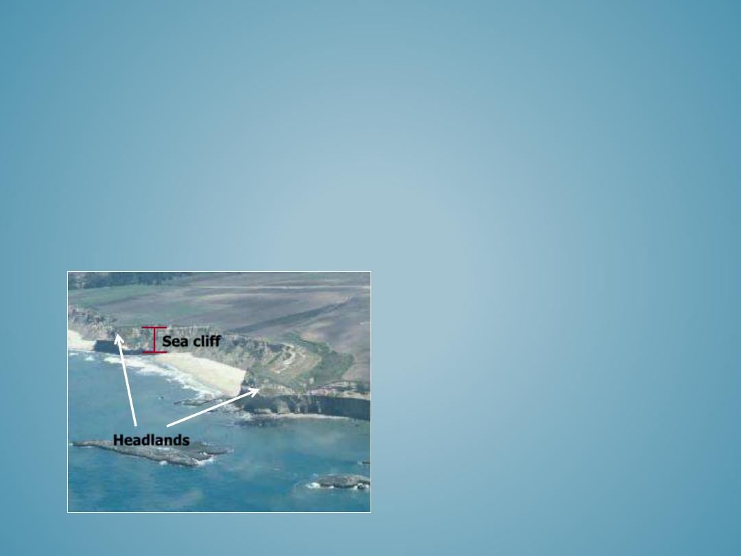
Sea cliffs are erosional landforms formed by the undercutting action of the sea against the
coastline.
•
The eroded sea cliff becomes notched inland where the waves erode the coastline and
eventually the overhanging land collapses into the ocean. This process causes the sea cliff to
slowly retreat inland eroding more and more of the coastline.
•
In undeveloped areas sea cliff related erosion does not pose a hazard. Unfortunately
extensive areas of the California and Oregon coast are developed near sea cliffs that are
threatened by the erosive force of the Pacific Ocean.
SEA CLIFFS
Headlands
Sea cliff
55
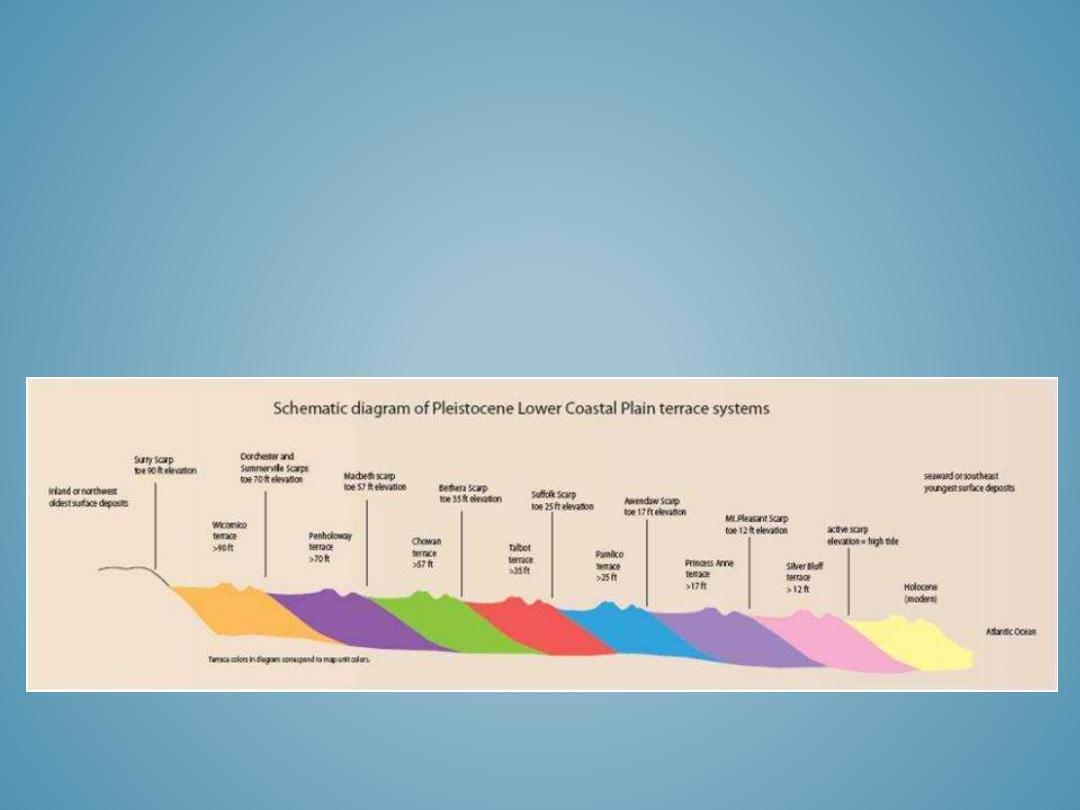
MARINE TERRACES
Marine terraces are wave-cut platforms that form a series of terraces that
progressively increase in elevation and age away from the modern coastline.
Marine terraces usually form as a result of either sea-level changes, tectonic uplifting,
or a combination of both processes.
Marine terrace are composed of shallow to deep marine deposits and often contain
fossil remains which provide a method for relative age dating.
Scarps form the boundaries between successive marine terraces and often mark
some indicator of landscapes response to environmental changes.
•
Ice sheets and Alpine Glaciers
•
Ice Field and Ice Caps
•
Piedmont Glacier
•
Tidal Glaciers and Icebergs
•
Glacial U-shaped Valleys
•
Fjords
•
Hanging Valleys
•
Cirques and Cirque Glaciers
•
Arêtes, Horns, Cols
•
Lateral and Medial Moraines
•
End and Terminal Moraines
•
Paternoster Lakes
•
Kettles
•
Erratics
•
Drumlins
•
Outwash Plain
GLACIAL LANDFORMS
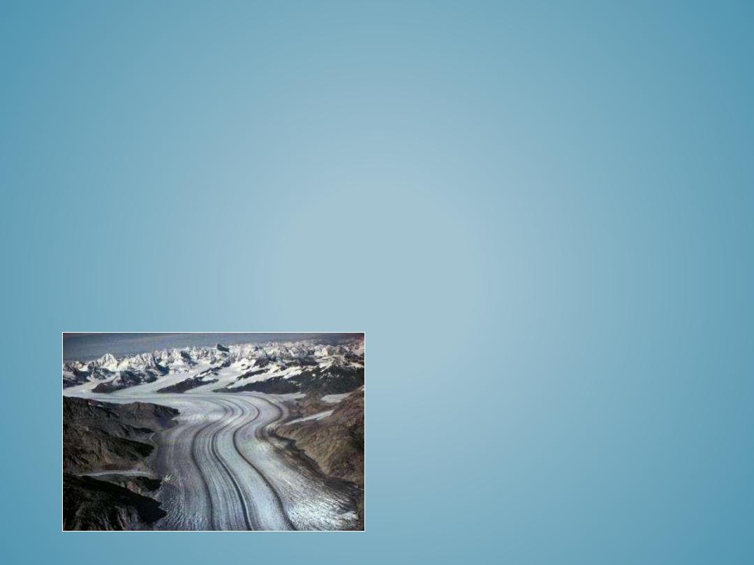
Glaciers are large masses of moving ice. Because glaciers
are “frozen” they are part of the Earth’s cryosphere,
which accounts for 77 percent of all Earth’s freshwater.
Glaciers are very sensitive to the slightest temperature
changes. Over Earth’s geologic history the spatial extent
and size of glaciers has expanded and shrunk numerous
times. As a result, glacial landforms can be found in
locations that currently have no active glaciers or
glaciation processes. Presently, glacial landforms occur in
two distinct geographic regions, high latitude polar
environments and high altitude mountain environments.
In this section we will explore glacial landforms from their
present context and from a historic look into the past.
Alpine Valley Glacier in Alaska.
• Cirques are bowl-shaped eroded, depressions near-mountain top ridges where snow
accumulates and forms the head of an alpine glacier.
• Glaciers in this early phase of formation are often referred to as cirque glaciers. The
confluence of multiple cirque glaciers merges to form a valley glaciers. Cirque glaciers
feed valley glaciers a relatively steady source of new snow.
• When glaciers retreat, the cirque is often the last part of the glacier to melt.
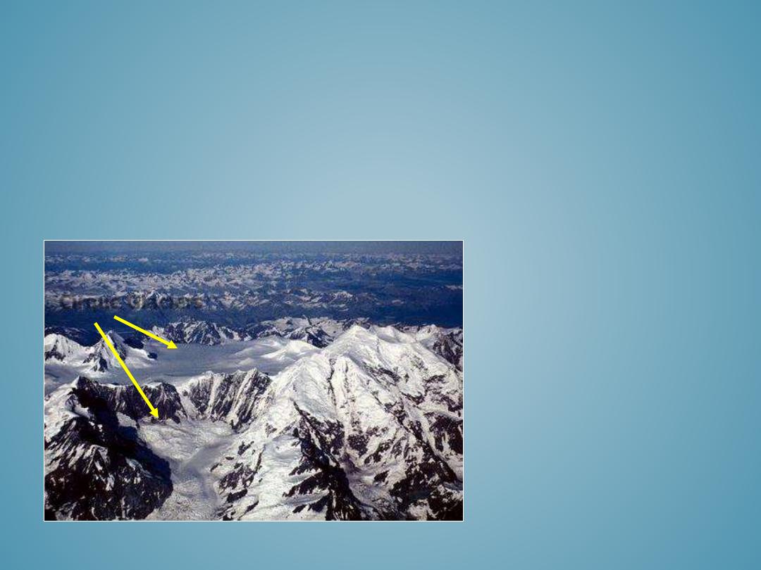
CIRQUES AND CIRQUE GLACIERS
Cirque Glaciers
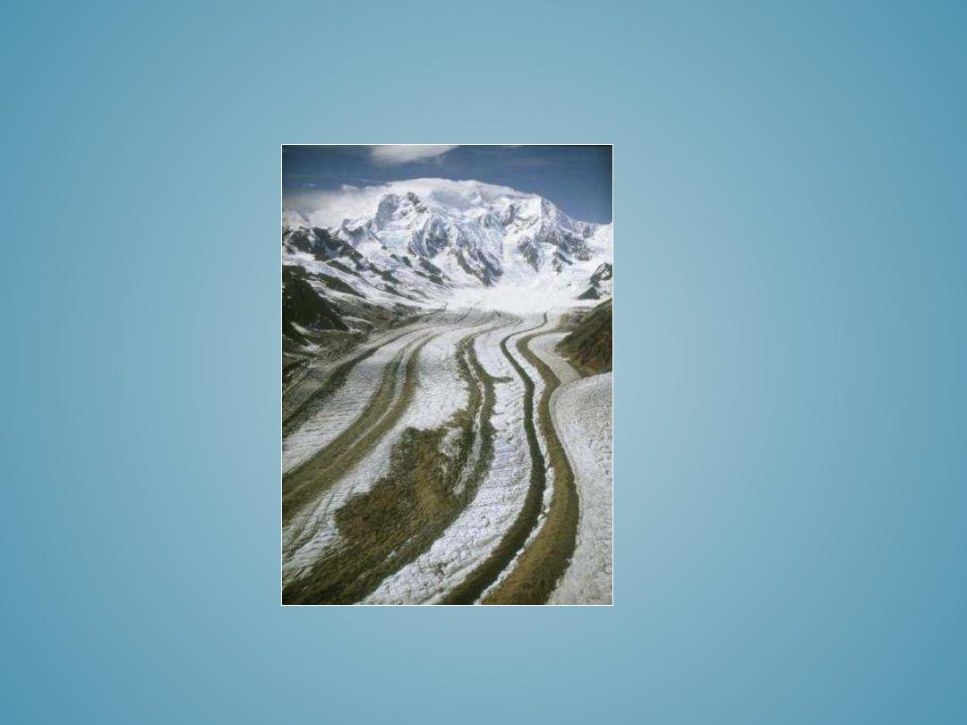
LATERAL AND MEDIAL MORAINES

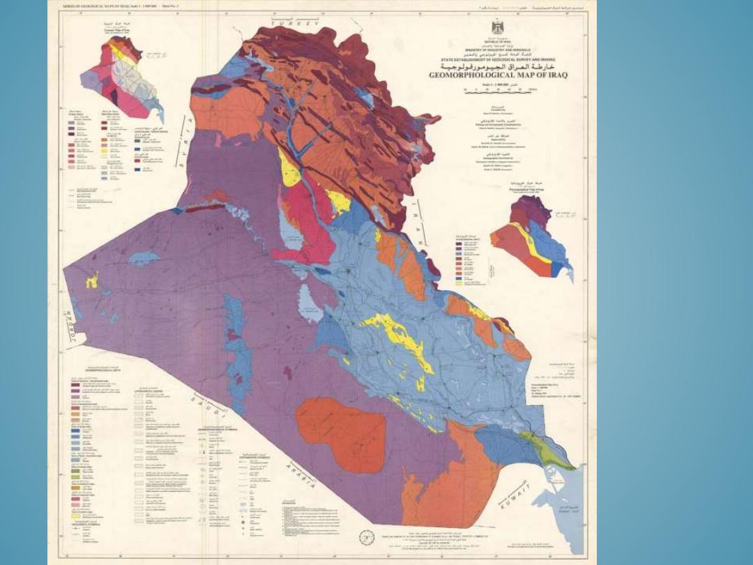
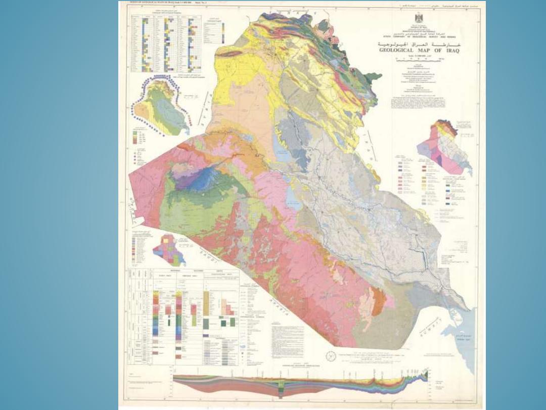
GEOMORPHOLOGICAL
MAPPING
59